OS Explorer map OL24, The Peak District – White Peak Area: Buxton, Bakewell, Matlock & Dove Dale – I own this map, and had visited it before starting this blog. Visited again for this post 30th April 2022.
Google Maps location links: Buxton, Earl Sterndale, Miller’s Dale, Castleton, Bakewell, Dovedale
I came to this map area on a short holiday with the Dearest Progenitors on a bank holiday weekend, staying in a holiday cottage in the village of Earl Sterndale, vaguely near Buxton, in the southwestern area of the Peak District. We stayed three nights, arriving on a Saturday and departing on the Tuesday, and spent the holiday like most trips with my parents go: going on an outing of some kind, usually a walk, for a few hours each day, maybe going out again for dinner, and spending the rest of the time lazing around in and around our holiday cottage, which is always nicely relaxing!
As blog readers may remember, I’ve posted about the Peak District reasonably recently, but that was about a trip to the northern area, the Dark Peak. The southern area, or White Peak, has a very different landscape: no high, round-topped hills with misty uncultivated moors on top; instead think somewhat lower, grass-covered hills, with most of the land cultivated in “dry-stone walls and sheep” mode. There are also deep narrow dales cutting through the landscape, and some of the hills are very dramatically craggy despite their small size.
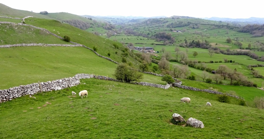
Earl Sterndale, where we were staying, was a small village sitting fairly far up a little valley, which was great for short walks out from the cottage – one could tramp up the side of the valley in just ten or so minutes, at which point a view several miles long in most directions would open up across the neighbouring valleys. I did little walks such as this a couple of times, and always enjoyed them, not least because of the cute, energetic lambs that would chase each other around me!

From one such walk, I could also see over to the hills Parkhouse Hill and Chrome hill, which are very sort of sharp and pointy, with narrow rocky ridges at the top. On this occasion, I didn’t go up those hills, since I’m informed that it’s best done in thoroughly dry weather since the way up is rather steep and slippy, but I’d very much like to come back and climb them. Wikipedia also tells me that Parkhouse Hill is notable as a hill behind which a “double sunset” can be seen at certain times of year from a certain location: the sun sets by falling behind one side of the hill, but then pops out again briefly from the other side before dropping completely behind the horizon again.

I should also mention that our cottage was right next to the fairly recently-closed village pub, which bore the curious name The Quiet Woman, and still sported a couple of rather creepy pub signs featuring a headless lady holding a foaming glass of beer. I didn’t look into the origin of the pub name, but it feels as if it should be named for a local ghost story – perhaps for the landlady of a previous, burned down inn on the site, who was villainously taken financial advantage of for her quiet nature, deprived of her pub and somehow ended up beheaded, but returned to haunt her oppressors. I unfortunately didn’t get a photo of the sign, but you can find plenty on the internet!

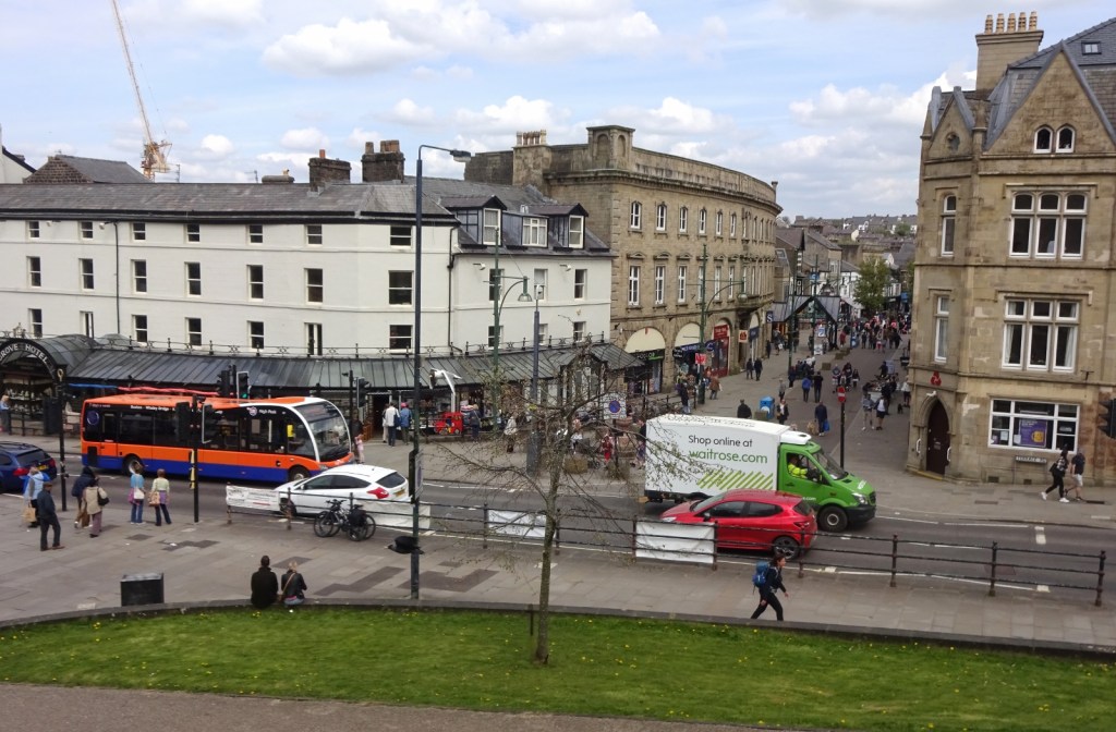
The nearest town to Earl Sterndale is Buxton, and we went there a couple of times on the trip, once for some shopping and a quick explore, and once for dinner in a Thai restaurant. It was a nice place of the “English spa town” variety, with some imposing Georgian terraces around the spa itself. I enjoyed the big railway viaduct that from some points dominates the town – despite being at the end of the line from Manchester when it comes to passenger services, the first few miles of the closed routes through to Matlock and Ashbourne are still open for freight, and each of these branches off before Buxton station and makes its separate way through the town; in the Ashbourne line’s case, on the viaduct in question.

Of our longer walks, one took us to the area around Castleton, which I’ve visited before and, indeed, being over in the Dark Peak map area, was discussed in my post about that area. I therefore won’t tell you about that walk in detail, but will leave you with this photo of a part of our walk that I found very cool indeed – we were surprised to find when walking on this path below Mam Tor that it is in fact a proper road, but one that seems to have in pretty recent times mostly disappeared through some kind of landslip, leading walkers to have to clamber up, down and around the remaining bits of road surface. Very post-apocalyptic!


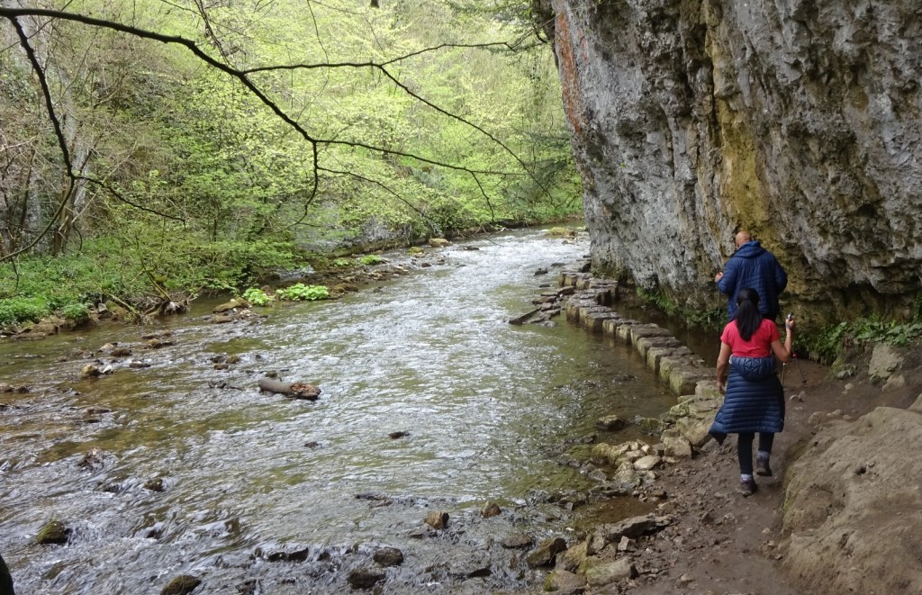
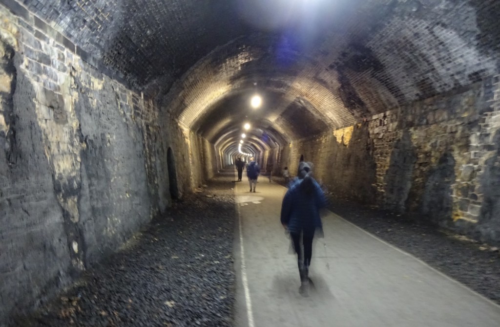
The other longer walk we did was indeed in this map area, and took us partly along a bit of the Monsal Trail, and partly alongside the River Wye as it winds through Chee Dale. It was a very nice walk! The Monsal Trail is the old Buxton-Matlock railway line, converted into a walking and cycle path, along with all the associated dramatic viaducts and tunnels. Being an old railway line, it’s a nice, easy walk – flat, wide, no obstructions, easily accessible – despite being through hilly country, which makes it very popular. That said, while there were definitely plenty of other people around, it was not nearly as busy as I’d feared for our walk!

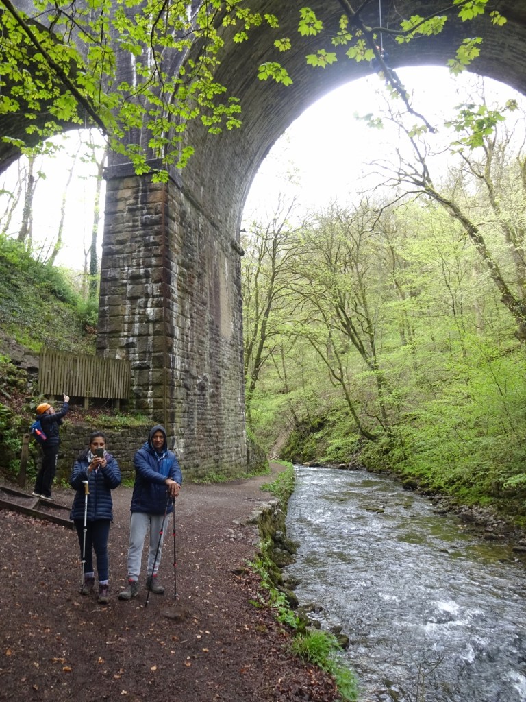
As flat and accessible as the Monsal Trail was, the Chee Dale section of our walk was rather the opposite. The route was really pretty, taking us through a deep, wooded river valley; Father Dearest enjoyed pointing out various plants and birds as we passed.
However, it was also much more technically challenging than I expected. When picking the route, I’d had in mind that the Dearest Progenitors aren’t quite as spry as they once were, so we wanted something that wouldn’t be overly steep or uneven. However, while there wasn’t much altitude change involved, that doesn’t mean the path is flat and even; just that it doesn’t climb consistently for a long while, so you never quite know what you’re going to get. I knew in advance about the stepping stones through the River Wye at one point, but wasn’t prepared for how often the path requires scrambling up and down steep rocky inclines, since the valley is quite steep-sided and it evidently wasn’t possible to keep the path right down next to the river at all times. Fortunately, my parents and I managed it without issue. It was a beautiful walk!


And… that was it, really! One last thing before I leave you: I’m writing up this post – or at least, the first draft of this post, which I’ll expand on and post in a few months when I get around to this point in the posts queue – on the train home, which has also been a mildly exciting experience, since at Nottingham I got onto the East Midlands Railway’s Liverpool-Norwich service. (I’ll be getting off at Ely.) There’s nothing wildly special about this service, but it’s always appealed to me as a very random pair of cities to have a direct service between them, so I’m glad to have got it! It’s served by rather shabby-looking 2-carriage diesel trains, which I’ve seen before looking particularly sad next to the shiny new Greater Anglia bi-modes at Norwich and Ely, so I wasn’t expecting much from the passenger experience, however I was pleasantly surprised here – the trains have clearly been refurbished reasonably recently: the seats were comfortable, nicely spaced and fairly new-looking, and the interior was generally fairly bright and clean. A nice journey home after a nice holiday!
Previous visits
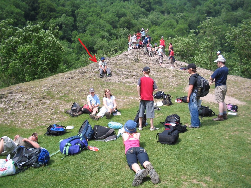
I’ve been to this map area twice before that I can think of, the first of which was way back in 2005, on a school geography trip in year 7. The trip was to Dovedale, around ten miles to the south of the bit of the River Dove I could see from my short walks from the Earl Sterndale cottage on this recent trip, and a pretty dramatic valley with some interesting caves. I don’t remember a whole lot about the trip, so you’ll have to make do with these pictures!

My post about the Dark Peak area told you of the trip I made to the Peak District in June 2011, where my parents brought me and my friend Geochunderer up so that he could lead me on a practice hillwalk, in preparation for the Duke of Edinburgh’s Award expeditions I’d be doing in Wales soon after. While our walk was in that map area, we weren’t there for the whole trip: we drove up on the Saturday, stayed the night in a hotel and haddinner in a restaurant that I haven’t been able to identify. The next morning, we drove for a bit more, and had breakfast somewhere before continuing to Castleton to start our walk. While I don’t know where the hotel and dinner were, from some shop signs visible in my photos I’ve been able to identify the breakfast stop as in Bakewell, which is in this map area!


I have a suspicion I’ve been to Bakewell another time, or at least explored it more than my pictures of this trip show. But I can’t remember when, or find any evidence of such a trip, so oh well!