OS Explorer map 154, Bristol West & Portishead: Congresbury & Chew Magna – I do not own this map, and had not visited it before starting this blog. Visited for this post 20th December 2025. Map area link. Google Maps location links: Chepstow, Severn Tunnel Junction Intro Regular readers will know that I enjoy doing … Continue reading 154: Chepstow to Severn Tunnel Junction
Tag: walking
366: Stirling & the Ochils
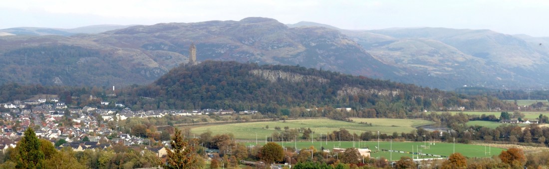
OS Explorer map 366 – Stirling & Ochil Hills West Alloa & Dunblane. I do not own this map, and had not visited it before starting this blog. Visited for this blog 18th October 2025. Map area link. Google Maps location links: Dunblane, Menstrie, Stirling, Tappoch Broch, the Kelpies, Falkirk Wheel, Craigmillar Castle Just four … Continue reading 366: Stirling & the Ochils
Special: Career break!

I've mentioned a few times in recent posts, that I left my job in summer 2024, and planned to have a couple of months' break before starting the next one – see, especially, the first section of my Lochnagar post for some more details about my ideas. It always seems a little odd that for … Continue reading Special: Career break!
OL59: Ballater, Morven & Loch Kinord

OS Explorer map OL59, Aboyne, Alford & Strathdon – I do not own this map, and had not visited it before starting this blog. Visited for this post 5th July 2024. Map area link. Google maps location links: Ballater, Morven, Loch Kinord, Dinnet, Aboyne, Kincardine O'Neill, Aberdeen In my previous post, I told you about … Continue reading OL59: Ballater, Morven & Loch Kinord
OL53: Lochnagar
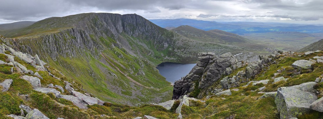
OS Explorer map OL53, Lochnagar, Glen Muick & Glen Clova: Ballater & Balmoral – I do not own this map, and had not visited it before starting this blog. Visited for this post 2nd July 2024. Map area link. Google Maps location links: Aviemore, Loch Morlich, Fords of Avon, Braemar, Loch Callater, Lochnagar, Gelder Shiel, … Continue reading OL53: Lochnagar
298: Nidderdale & Ripon
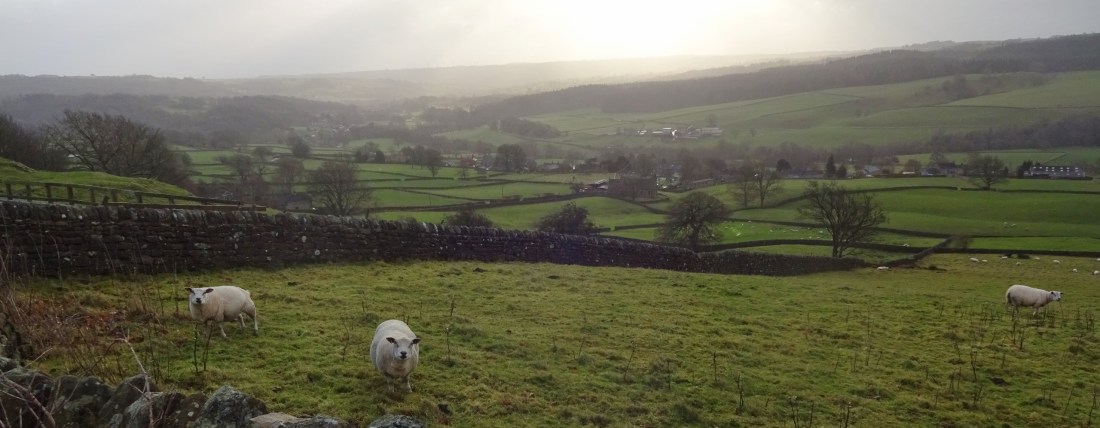
OS Explorer map 298, Nidderdale: Fountains Abbey, Ripon & Pateley Bridge – I own this map, and had visited it before starting this blog. Visited again for this post on 20th December 2023. Google Maps location links: Long Eaton, Harrogate, Knaresborough, Bishop Thornton, Pateley Bridge, Brimham Rocks, Ripon, Masham, Kettlewell I'll write here about a … Continue reading 298: Nidderdale & Ripon
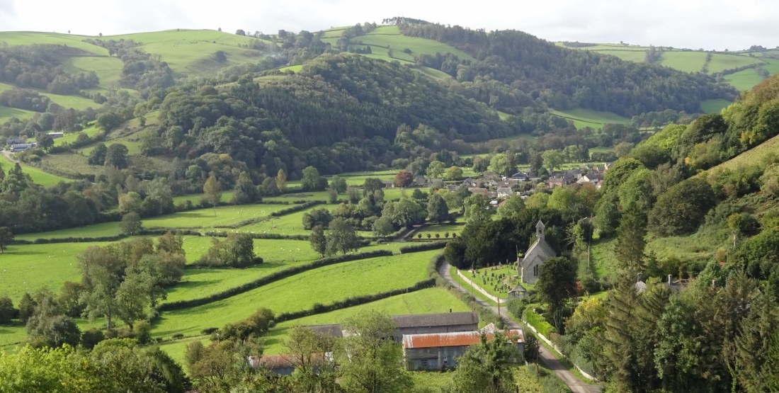
216: Clun Forest & Corndon Hill

OS Explorer map 216, Welshpool & Montgomery: Bishop's Castle – I do not own this map, and had not visited it before starting this blog. Visited for this post 4th October 2023. This is the last of three posts about my walking trip in Wales and Shropshire from 3rd-5th October 2023. Google Maps location links: Newcastle-on-Clun, Edenhope Hill, Corndon … Continue reading 216: Clun Forest & Corndon Hill
201: Knighton
OS Explorer map 201, Knighton & Presteigne: Kington & Hay-on-Wye – I own this map, and had visited it before starting this blog. Visited again for this post 4th October 2023. This is the second of three posts about my walking trip in Wales and Shropshire from 3rd-5th October 2023. Google Maps location links: Knighton, … Continue reading 201: Knighton
200: Llandrindod Wells

OS Explorer map 200, Llandrindod Wells & Elan Valley: Rhayader – I own this map, but had not visited it before starting this blog. Visited for this post 3rd October 2023. This is the first of three posts about my walking trip in Wales and Shropshire from 3rd-5th October 2023. Google Maps location links: Llandrindod … Continue reading 200: Llandrindod Wells
206: Between Daventry and Banbury

OS Explorer map 206, Edge Hill & Fenny Compton: Badby, Kineton & Middle Tysoe – I own this map, but had not visited it before starting this blog. Visited for this post 30th September 2023. Google Maps location links: Nether Heyford, Chipping Warden, Middle Tysoe, Moreton-in-Marsh Intro Over the last couple of years, I've come … Continue reading 206: Between Daventry and Banbury
