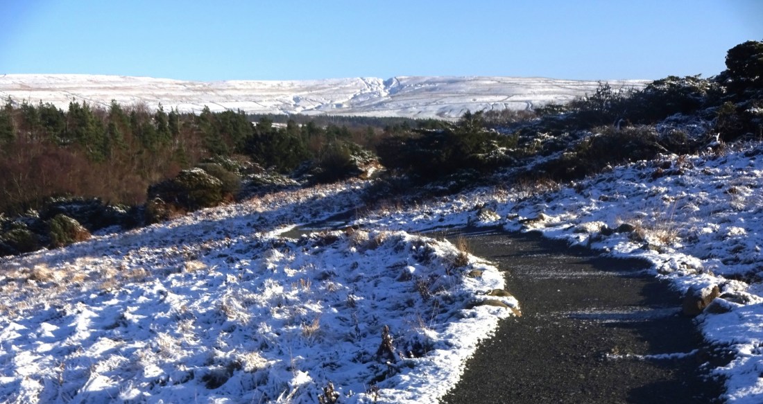
OS Explorer map OL31, North Pennines: Teesdale & Weardale – I own this map, but had not visited it before starting this blog. Visited for this post 4th January 2022. Google Maps location links: Tow Law, High Force, Wolsingham My previous post told you of the week's holiday that Vesper and I took in the … Continue reading OL31: North Pennines
Tag: walking
307: Tow Law
OS Explorer map 307, Consett & Derwent Reservoir: Stanhope – I own this map, but had not visited it before starting this blog. Visited for this post 3rd January 2022. Google Maps location links: Tow Law, Hedleyhope Fell nature reserve, Parkhead Station, Hexham Attentive readers may remember mine and Vesper's May 2021 trip to the … Continue reading 307: Tow Law
OL13: White Castle & Brecon Beacons East
OS Explorer map OL13, Brecon Beacons National Park: Eastern Area – I own this map, and had visited it before starting this blog. Visited again for this post 29th December 2021. This is the second of three posts about my trip to the Wye Valley with the Dearest Progenitors. Google Maps location links: White Castle, … Continue reading OL13: White Castle & Brecon Beacons East
228: Littleport
OS Explorer map 228, March & Ely: Chatteris, Littleport, Welney & Denver Sluice – I do not own this map, and had not visited the area before starting this blog. Visited for this post 3rd October 2021. Google Maps location links: Ely, Littleport Since I moved out of my childhood home to go to off … Continue reading 228: Littleport
337: Peebles
OS Explorer map 337, Peebles & Innerleithen: Eddleston & Ettrickbridge Traquair & Yarrow – I own this map, and had visited it before starting this blog. Visited again for this post 24th September 2021. Google Maps location links: Peebles, Great Polish Map of Scotland My previous post told you of a short stop I and … Continue reading 337: Peebles
370: Lomond Hills
OS Explorer map 370, Glenrothes North, Falkland & Lomond Hills: Auchtermuchty & Cupar – I own this map, and had visited the area before starting this blog. Visited again for this post 24th September 2021. Google Maps location links: Bunnet Stone, East Lomond I came to this map area with my parents, as a stop … Continue reading 370: Lomond Hills
OL21: the South Pennines (around Haworth)
OS Explorer map OL21, South Pennines: Burley, Hebden Bridge, Keighley & Todmorden – I own this map, but had not visited it before starting this blog. Visited for this post 12th August 2021. I came to this map area for for a short-ish holiday with my friends Erithacus, Vesper and Millicent. As regular readers may … Continue reading OL21: the South Pennines (around Haworth)
330: Moffatdale & St Mary’s Loch
OS Explorer map 330, Moffat & St Mary’s Loch: Megget Reservoir – I own this map, but had not visited it before starting this blog. Visited for this post 10th July 2021. This is the fourth of six posts about my trip to Wanlockhead in Dumfries and Galloway with my school friends Cabbage, Joystick and … Continue reading 330: Moffatdale & St Mary’s Loch
OL16: Cheviot Hills
OS Explorer map OL16, The Cheviot Hills: Jedburgh & Wooler – I own this map, and had visited it before starting this blog. Visited again for this post 9th July 2021. This is the second of six posts about my trip to Wanlockhead in Dumfries and Galloway with my school friends Cabbage, Joystick and Climbing … Continue reading OL16: Cheviot Hills
308: Durham
OS Explorer map 308, Durham & Sunderland: Chester-le-Street & Peterlee – I own this map, and had visited it before starting this blog. Visited again for this post 8th May 2021. Google Maps location links: Durham, Langley Park, Hill Top, Bearpark As you'll know from my last few posts regarding my trip down to Dorset … Continue reading 308: Durham


