OS Explorer map 174, Epping Forest & Lee Valley: Hertford & Harlow. I own this map, and had visited it before starting this blog. Visited again for this post 14th January 2023.
Google maps location links: the London Stone, Victoria Park, Leyton Flats, Chingford, Redbridge, King George Hospital, Brickendonbury
Regular readers may remember my Littleport and Hunstanton posts, describing my walk from Cambridge to Hunstanton that I did in stages in 2021-22 – that is, walking for a day whenever I felt like it, then returning to my previous finishing point to continue on a future date. Since finishing that walk, I’d been wanting to do another something similar, and decided on trying to walk from London to Cambridge – I travelled between London and my Cambridge home regularly for work, so thought it’d be satisfying seeing the full distance “on the ground”, as it were. I recently added a map of walks page on the blog, where there’s a zoomable map to which I add any new long walks I do; you can see this day’s walk on there, and indeed the rest of the London-Cambridge walk which I later completed!
On this Saturday morning in January, therefore, I got on the train down to London to start my walk: my first day would take me from central London out to Chingford, at the southern edge of the main mass of Epping Forest.


I wanted to start my walk somewhere that feels like the centre of London in some sense: I considered Trafalgar Square, but in the end settled on starting from the London Stone on Cannon Street – the Stone is the “heart of London” in various traditional storybook senses, which is appealing, but I admit that I may also have been influenced by the fact that it’s fairly far east in Central London, making my walk a little shorter!

From the Stone, I made my way northwards between the skyscrapers, banks and old buildings of the City, passing through Spitalfields to arrive in Shoreditch, where I met my friend Little S, who’d be accompanying me for the next few hours. We walked the length of Shoreditch High Street, before joining the Regent’s Canal, and following it for a mile or so, appreciating the very eclectic selection of buildings that line it – run-down dusty warehouses, a set of studios made of shipping containers, and my personal favourite, a block of flats that had clearly been converted from an old warehouse, as the little rooftop cranes had been retained, with balconies below them attached to a “rope” hanging off the crane.
We left the Canal behind to walk through Victoria Park, and while it was a little too refined a park for my tastes, I enjoyed discovering the Victoria Park alcoves, remnants of (the 18th-century reworking of) Old London Bridge.

By the time we got to the other end of the park, we’d been walking for a good few miles and were in need of a rest, and Little S’s phone telling us we were near the delightfully named Thingy Café, we had to take a look. It turned out to be really cute, and I had an early, uh, first lunch of a very nice veggie sausage sandwich with some equally pleasant chai latte. I don’t know what was in the tangy “thingy sauce”, but I liked it!


After our café sit-down, Little S whizzed off home from the nearby Hackney Wick Overground station, while I got on with walk. It was unfortunately a rather undecidedly rainy day, stopping and starting, occasionally getting heavy enough that I’d put my waterproof trousers on but quickly stopping again. I crossed the River Lee into the Olympic Park, also entering this map area at that point, previously having been in the map 173: London North, which I’ve posted about before. From there, then continued through residential areas of Stratford and Leyton, by which point London had lost its big-city feeling: after Stratford there were no more townhouses, blocks of flats and fancy cafés; instead it was all suburban terraces and little convenience stores.

Through Stratford and Leyton was the last long stretch of urban walking I’d have in the day: after Leyton I got onto Wanstead Flats, an open green area that, technically, forms the southernmost portion of Epping Forest. While the biggest (and actually forested) area of Epping Forest is further north, stretching five miles or so from Chingford through to Epping; the Forest also includes a long “tail” of grassland, heaths and wetland streching well to the south, of which Wanstead Flats is the southernmost.

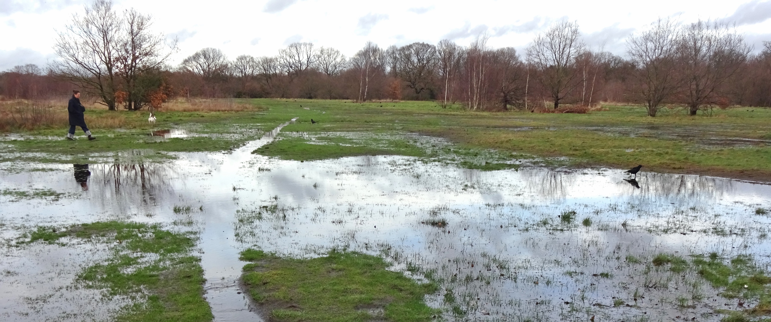
The bit of Wanstead Flats I entered wasn’t particularly inspiring, consisting of a set of thoroughly waterlogged playing fields overlooked by some distinctly dingy pastel-green blocks of flats.


As I continued northwards, entering Leyton Flats, things quickly got much prettier; it was a green space very much to my taste, being nicely wild-feeling: little scrubby bushes, ponds and grassland with nothing but the earth paths (and slightly distant traffic noise) to distract from them. Unforuntately, things also became even wetter, and I often had no option but to splash my way through ankle-deep puddles, but oh well!
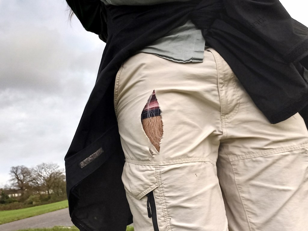
The weather – if not the ground – had dried up by this point, and I took off my waterproof trousers to, a little later, look down and discover that I somehow had a giant rip in my my shorts, treating passers by to a nice few inches of my thigh and stripy underpants. I’d be too hot back in the waterproofs, though, so I just continued, just strategically holding my waterproof jacket over my right arm if I ever felt too heavily exposed…

The pleasant surroundings continued for the whole of the remaining few miles of my walk, though I made a couple of short detours: one to a giant Tesco to buy a late second lunch, and another when I went slightly the wrong way and somehow ended up walking past my mother’s old senior school, Woodford County High.


I left the Forest for the last time opposite an Epping Forest visitor centre, one of the prettiest Premier Inns I’ve ever seen in a half-timbered old hotel building, and the interesting Queen Elizabeth’s Hunting Lodge. I then got on the train at Chingford, and was on my way home. A good day!
Previous visits
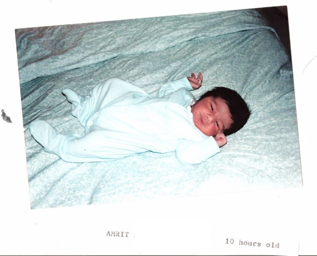
This map area is an important one for me, because it’s where I was born! That notable event happened at the King George Hospital in Ilford; and my parents and I lived in nearby Redbridge for the first year or so of my life, at which point we moved to Northampton. And my maternal grandparents, uncle, aunt and cousins Guacamole and Fashionable Cousin lived there until I was about fourteen, so during my childhood we visited regularly.
Here are some photos of me and various family members in this map area for you to enjoy, including the first ever photo taken of me!


The other place in this map area I can think of having visited before is Brickendonbury, an estate in Hertfordshire owned by some agency of the Malaysian government, where there is an annual celebration of Malaysia’s national holiday. My father and various cousins having grown up in Malaysia, occasionally during my childhood we’d attend that, almost exclusively for the purpose of all the food stalls, where one could get all kinds of things not normally easily available in the UK.


