OS Explorer Map 443, Ben Klibreck & Ben Armine – I own this map, but had not visited it before starting this blog. Visited for this post 12th August 2019 (but also 27th May 2019 – see below). This is the third of three posts about my summer 2019 walking trip with Hueler in the north of Scotland.
My previous post told of the latter half of mine and Hueler’s first day of walking on our three-day hike from Kinbrace through to the Crask Inn; and of our overnight experience in the bothy at Gearnsary. We entered this new map area shortly into our second day of walking, and stayed in it for the whole of the next two days, covering the bulk of our trip – so this will be a bit of a bumper post!

First though, I should mention: I actually visited this map area earlier in 2019 too, in May, at the end of the Chase Game, when my friend Climbing Programmer, equipped with a location signal from a GPS tracker I was carrying, chased me around the country for a few days – see my report about the game for more details.
Now, normally I just write about my first visit to a map area (or my first visit since starting the blog), however in this case I realised that that would mean missing out the bulk of my trip with Hueler. Since that later hike was so exciting, I decided to delay writing about this map area so that I’d be able to talk about it too. I’ll therefore be continuing the narrative of the hike first, before mentioning my visit to the Crask Inn during the Chase Game at the end.

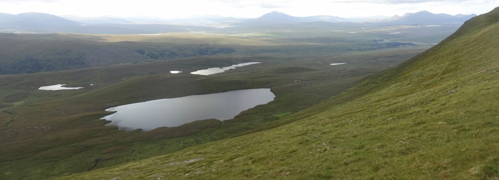
To the south-west of Gearnsary, where we started the day’s walk, sits the Armine Forest, a big empty (treeless) expanse, sitting a couple of hundred metres higher than the land around it. At its eastern side are the hills Ben Armine and Creag Mhòr, while it’s bounded at the northwestern side by the glen in which sits Loch Choire. Ben Klibreck, an isolated Munro (i.e. a Scottish peak over 3000ft tall) is on the other side of the loch.
Our plan for the day (scroll down for map) was to, from Gearnsary, continue along the track we were following the previous day for a few miles, until we’d turn left onto a track that would take us southwards along the eastern edge of the Armine Forest. We’d then ascend to the Forest and hopefully go up Ben Armine itself, before walking across the Forest to one of two bothies in the area, where we’d overnight.
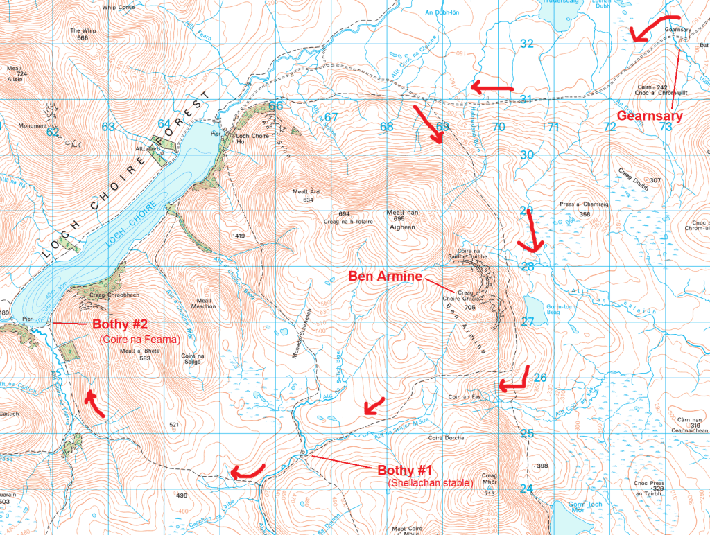
The first of these bothies sits solidly in the middle of the Armine Forest, while the other is a few miles further west, being down on the shores of Loch Choire itself. This brochure from when the Loch Choire estate was recently up for sale tells me they are called the Shellachan Stable and Coire na Fearna bothy. The Shellachan Stable was our intended next overnight stop, making the day’s walk around 11 miles; but we decided that if we were approaching that point in good time and not feeling too tired out, we could continue another 4 miles to Coire na Fearna to give ourselves a more leisurely final day.
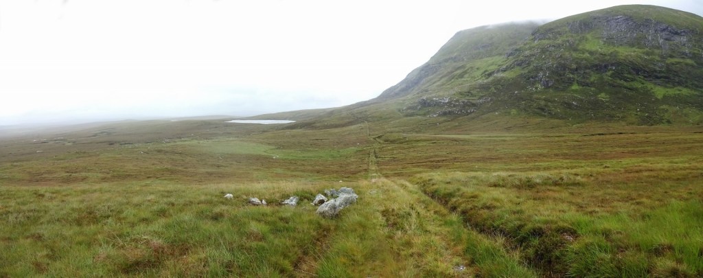
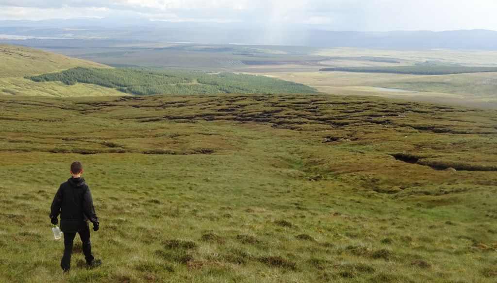
We set off from Gearnsary a little later than planned, perhaps, but otherwise well after an entirely adequate night’s sleep in the admittedly rather creaky bothy. The first sections of the walk passed pleasantly enough, andd with no barriers bigger than mud, squelch and streams as we made our way along the track and then the footpath. It was a grey, moist day, but not raining, and the view to our left was very desolate and empty; while Ben Armine on our right looked rather imposing – the mountain is rather round and flat on top, but has very steep slopes on the side leading down to our path.
For a mildly unpleasant aside, I unfortunately had moist feet: despite my ambition to be on the ball with my gaiters whenever things got damp, I’d neglected them when walking through long wet grass over to the stream at Gearnsary the evening before. Given the short distance, I didn’t even bother doing up my bootlaces, but this let my socks wick an astonishing amount of water down into my boots in just a minute or so – unfortunately through that one mistake I was damp of feet for the rest of the trip.
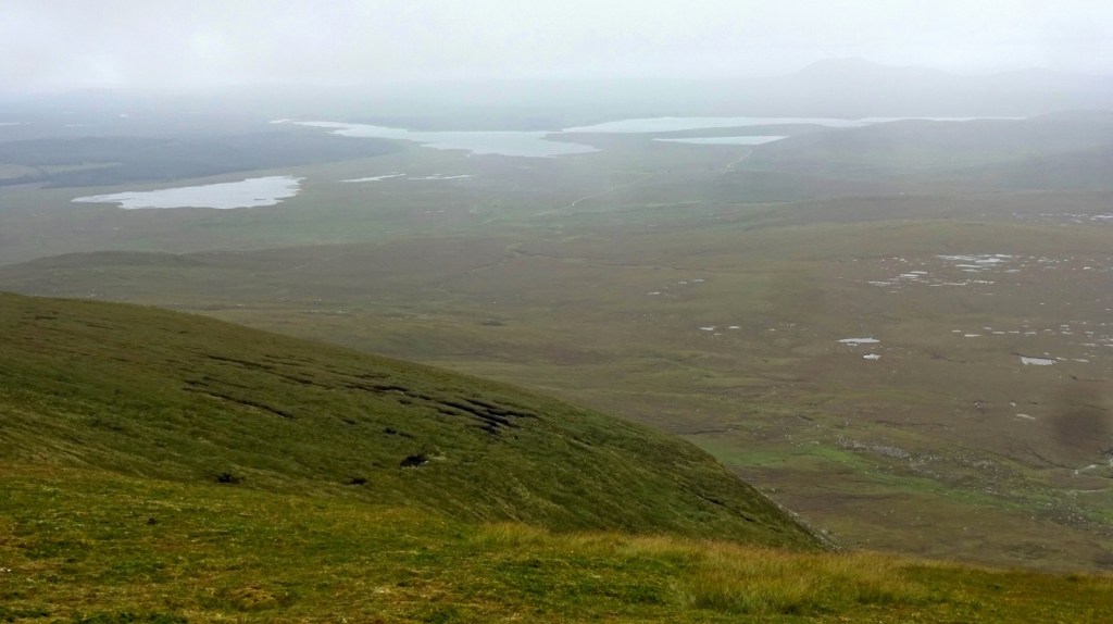
Nevertheless, the walk was going well, so after a lunch stop, we did indeed walk up Ben Armine. It’s not the most exciting hill ever, since it’s one of those annoying situations where the hilltop is flat enough that you can’t see out in all directions at once. However, you could see out really far across the low-lying plain to the east, and it was clearly visible how much higher the Armine Forest sits than the land around it. It would be good to come back on a clearer day! We were making pretty good time, and decided that we’d continue on to the second bothy, rather than spending the night at the Shellachan Stable.

Speaking of lunch, on this trip, I’d made the possibly questionable decision to pack some tinned oysters, pitta bread and squeezy Primula cheese for my lunches. Now I’m lacto-vegetarian (i.e., will eat dairy but not eggs or meat) on somewhat woolly animal-suffering grounds, but I will eat oysters, mussels and the like on the grounds that even among seafood they seem particularly unlikely to be able to suffer – not that I have particularly good evidence for this, having never looked deeply into it myself; I know that some people who’ve looked into it came to such a conclusion while others are suspicious. Given that, I picked the tinned oysters for being a rare option that was all of light, non-refrigerated, and a form of protein that my diet permits. (Though admittedly, I’m not very knowlegeable about diets/nutrition at all – the protein remark is only based on a vague memory of the “food groups” thing that was drilled into our heads at primary school.) I thought they were entirely adequate if not actively tasty, but several other people have told me it sounds apocalyptically disgusting, so I’ll make a note never to serve it at a dinner party. [1]

Having descended from the hilltop, we started walking across the Armine Forest proper, which was indeed very empty, and in parts quite flat, so that given the misty day it was hard to tell that we were fairly high up. We neared bothy #1, the Shellachan Stable, at about 4pm. It looked very solid, and bigger than either of the other two bothies we saw on the trip, but unfortunately we were precluded from having a nose around by how high the river was that sat between us and it: I had a brief go at crossing, but gave up when the water was above knee height and pushing alarmingly, so we had to just admire it from a distance.

In fact, there was rather a notable lack of bridges on the various streams and rivers in the area – there were a good few places where bridges claimed to exist on the map were missing, in some cases with some remnant of them to be found on the ground; others having left no trace. Despite having given up on fording Abhainn Srath na Seilge to visit the bothy, we just ended up having to do so another half a mile or so on, where fortunately it had widened out at least a little, and we got across in one piece.

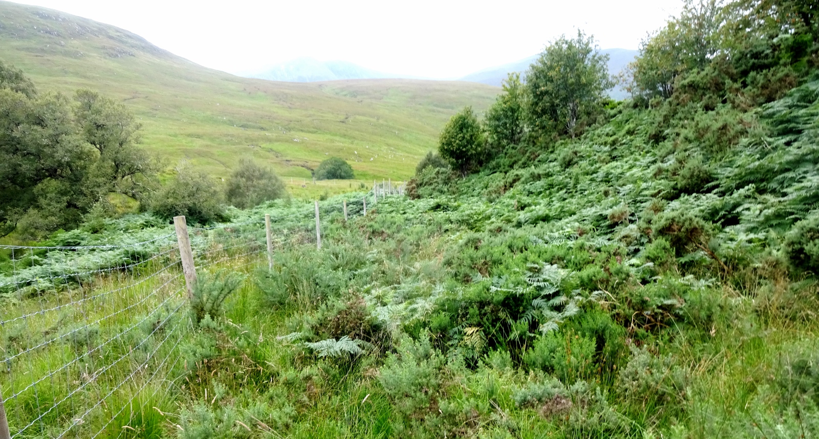
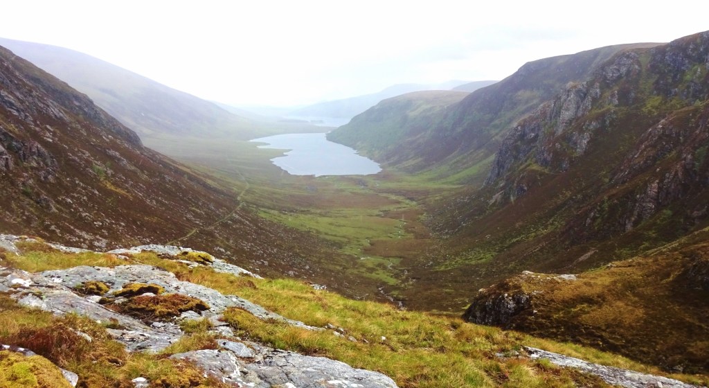
As we descended from the Armine Forest towards the shores of Loch Choire, things got gradually less featureless, and we soon found ourselves picking our way through various spiky bits of vegetation in an area well-provided with cute frogs.
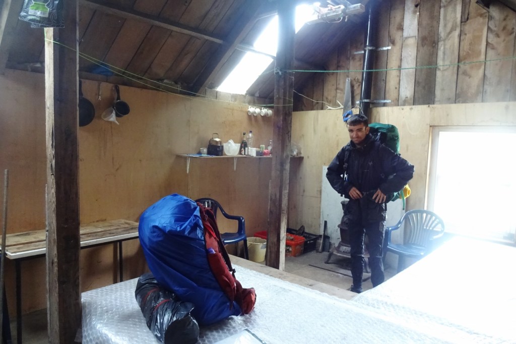
We arrived at the Coire na Feàrna bothy (which sits at the mouth of the valley of the same name that we’d just walked down) at around 6:30pm, and were really impressed with it. We probably had very low standards after Gearnsary the night before, as I understand most bothies are more like Coire na Feàrna, but it seemed luxurious to us: it was clean, fully wind- and waterproof; there were raised sleeping platforms, an iron wood stove (which we didn’t use), and various helpful tools, bits of long-life food and so on left behind by previous visitors.
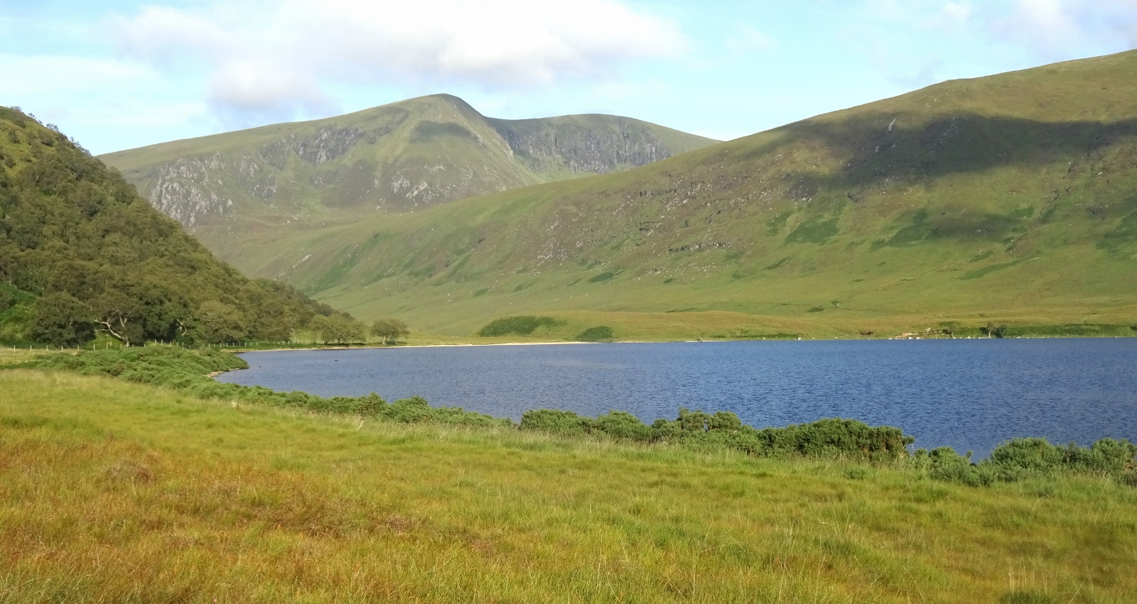

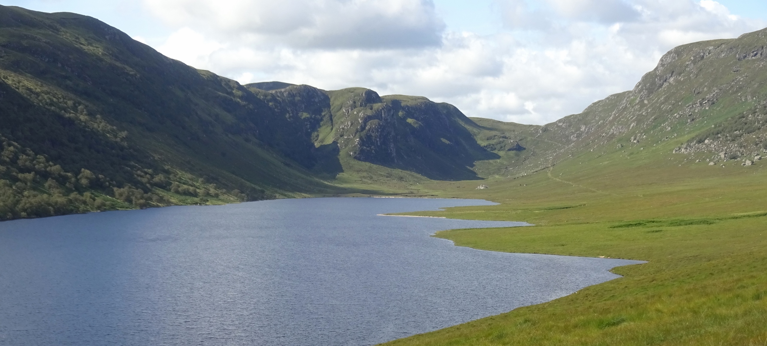
We couldn’t see it to full effect until the next morning but Loch Choire is a really beautiful spot. We were delighted the next morning to wake up to quite a fairly clear and bright day, with the sunlight making the loch a deep blue, and the hilltops miraculously cloud-free.
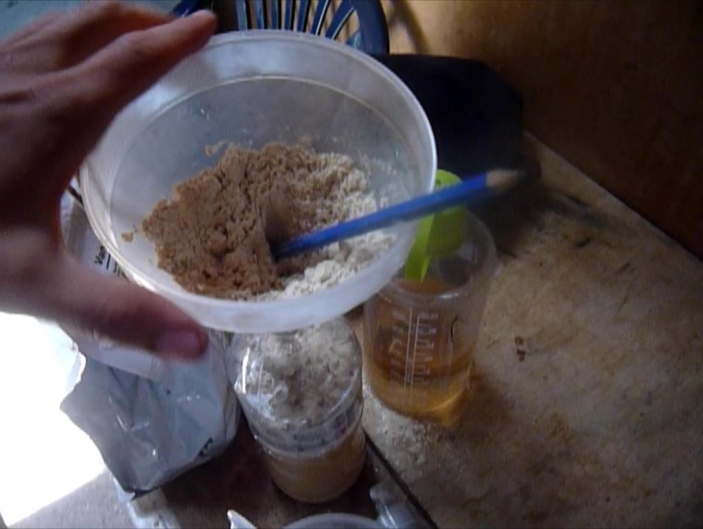
It was this evening that a very unfortunate discovery was made. As you heard in my last post, Hueler was sustaining himself on this trip entirely on the meal replacement drink Huel. Unfortunately, as I was preparing my instant pasta this evening, Hueler started to ready his Huel, but his Huel shaker was nowhere to be found – presumably it was still somewhere up on the Armine Forest, as he’d last used it for lunch just before we walked up Ben Armine.

Now Huel comes in powdered form, and needs to be combined with water either with a blender, or in a shaker equipped with a plastic mesh that breaks up the powder into a not-too-lumpy shake. Without his shaker, therefore, Hueler was left in a rather sticky situation – especially since we had no sealable container with a wider neck than a water bottle, so couldn’t get the Huel into anything else to shake it in. Here follows a transcript from the video Huel diary that Hueler kept to send to one of his friends – the person who got him into Huel, if I recall correctly:
I had an accident today. Lost the Huel shaker. So I’m eating it straight, like a hardcore Huel fan.
[Pause]
So, I can’t remember the first few years of my life very well, so I can’t be 100% sure about this statement. But I think that was the worst meal I’ve ever eaten. It’s a nice bothy though!
Yep, Hueler’s evening meal was indeed Huel powder, eaten with a spoon, each mouthful of powder washed down with a separate swig of water. Shudder. Fortunately, the next morning, a somewhat better solution was devised: we discovered that some helpful soul had left a funnel in the bothy, which with the help of a pencil to use as a ramrod, Hueler was able to use to get the powder into a bottle of water.
The next morning marked the start of our final day of walking on this trip. Having come further than originally intended on day 2, we actually only had about seven miles to cover on this last day to get us to the Crask Inn, so we started our morning in a fairly leisurely fashion, not planning to leave the bothy until around 9, 9:30am.
However, as we were breakfasting and generally readying ourselves, an idea occurred to me: it was a clear day, and Ben Klibreck was not too far off our route, given that we’d be skirting bits of it for much of the day. A little playing around with the OS maps app – don’t worry, I had paper maps too, it’s just quicker measuring distances on a digital one – revealed that adding an ascent of Ben Klibreck to our plans would make our day’s route around 15 miles, and we could dump our bags so that we could climb without them for most of the ascent – in other words, it seemed doable. Since we’d left things quite late, we’d plausibly not reach our destination until 7 or 8 pm, but the days were still fairly long, and the prospect was exciting enough that we decided to go ahead with it. My first Munro!

The first part of the walk, around the foot of Loch Choire, then along the length of Loch a’ Bhealaich, was easygoing and very pleasant in the ideal walking weather: sunny and clear, but cold enough that even very heat-sensitive me didn’t get too hot. There were some impenetrable brambles near the beginning (though possible we just lost the path), but we solved these by walking along the foot-wide strip of sand at the edge of Loch Choire, barefoot and carrying our boots as we occasionally stepped into the water to avoid an overhanging bit of bramble.

The very wobbly bridge across Allt Coire na Feàrna was very alarming, resulting in us trying to tread as lightly as possible on the planks that were neither obviously rotten nor missing, but we passed it without incident. For some reason we ended up talking about our confusions over the ever-thorny issue of population ethics as we walked the length of Loch a’ Bhealaich.

Reaching the Bealach Easach at the end of the loch, we stopped for a bit, had some some lunch, and then prepared ourselves to start our ascent of Ben Klibreck. We got everything we’d need for the next few hours into pockets so that we could leave our bags among the scrub, to pick them up for the last bit of our walk – when we collected them after our climb, it would only be around another four miles or so, straight and flattish, to the end of our walk at the Crask Inn. (Incidentally, the spot where we left our bags was also pretty much the place where Climbing Programmer caught me during the Chase Game a few months before – for details see below!)

We’d be walking up Ben Klibreck from perhaps a slightly odd direction, since I expect that most come from the west, where the road is, rather than the south. This means there weren’t any paths to follow for most of the way, however the ascent was mostly pretty shallow – the peak of Ben Klibreck is fairly steep-sided in all directions, but until the time came for the last couple of hundred metres of ascent, our way would be fairly gently sloped, approaching as we were along the long, shallow, flat-topped ridge to the south.
The ascent went smoothly if a little slower than anticipated – initially we were lumping our way through fairly dense scratchy scrub, but the vegetation thinned out quickly as we got onto higher, flatter ground. We also had some trouble with what I found out later are called peat hags – I was calling them “peat cliffs”at the time – winding clefts in the peaty ground, maybe six to ten feet deep. Over a section of our route, the hags were very inconveniently arrayed transversely across the direction we wanted to travel, giving us the perennial choice of whether to walk a really long way around each one to an easier crossing point, or attempt to climb down into it then up the other side.
Following the top of the ridge proper would have taken us over the little peak Creag an Lochain, but as neither of us felt like an unnecessary 60m or so of ascent, we made the possibly questionable decision to try to go around it, traversing its western slope. The slope turned out to be quite scree-y, so felt a little perilous, and we had to go back on ourselves, or go a little bit further up or down the mountainside to get around particularly slidey-seeming patches several times. However, as we approached the little saddle point between Creag an Lochain and the final ascent to Meall nan Con – as the highest peak of Ben Klibreck is called – we found the welcome sight of an actual path, so things got easier again.
The views from mountain slopes were already spectacular at this point. While everything to the east, where we’d been walking the last couple of days, was obviously blocked by the mountain itself, and The Crask Inn, where we’d be ending our walk, was visible at first but became hidden behind the hill Cnoc Sgriodain quite quickly – however we could see for miles to the west. It was still clear, but there were various patches of cloud approaching from the west, some darker and angrier-looking than others. We were high enough up that we could match up the individual clouds with the dark areas of ground that were their shadows.
Reaching the saddle point bit, there was another notable sight: we saw another party of walkers on their way up the mountain, and realised that they were the first other humans we’d seen in two days – the last person we’d seen being the farmer with his trailer of dogs two afternoons back!

The final push up Meall nan Con was much steeper than anything so far, and also quite exposed and very rocky – it needed a bit of rock scrambling rather than just walking. At this point, despite the fact that we’d been able to see the clear summit for the past hour, some clouds rolled in, and things got very windy and rainy very quickly, making things feel somewhat more perilous again, and making us quite doubtful as to the view we’d find at the top.

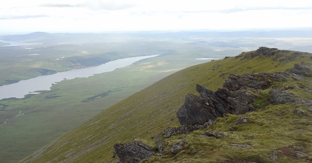
However, we were lucky: when we reached the summit soon after, at about 3:30pm, the sun came out again! The views were great – Ben Klibreck is the highest point for miles in every direction, and visibility was really good. We could see the route we’d walked over the past few days – Loch Choire was clearly visible, with Ben Armine, and Loch Badanloch. Within easy sight were Loch Naver to the north, Loch Shin to the south (though the Crask Inn was still hidden), and Ben Hope to the west. But we could also see a lot further than this, including to the sea in many directions. Most amazingly though, to the northeast, I think that we could see Orkney! It seemed pretty improbable, so I checked the direction against the map on my phone (somewhat improbably, I had 4G up there), and it was in exactly the right place, plus I couldn’t see anything else it could really be. So we could see Orkney, almost 60 miles away! Well worth the trip.
The clouds rolled onto the mountaintop again a few minutes after we reached it, enclosing us in fog, so we sat down for a quick rest in the little enclosed cairn at the summit – the other walkers were around too, but left before we did.

It was then time to retrace our steps for the four miles or so back to where we’d left our bags at the Bealach Easach. The weather stayed temperamental, with sunny periods interspersed with showers. The wind was coming from the west, and this meant that from the mountainside we could not only see each cloud before it came upon us, but could actually quite clearly make out the rain that was falling from each one – it was an odd experience being able to see rain when not being rained on, but knowing that very same rain would be on us in half an hour or so.
The walk went a little slower than anticipated, and when we got back to our bags it was clear that we wouldn’t get to the Crask Inn, where we’d booked to have dinner as well as camp for the night, until around 8pm. I’d lost the miraculous phone signal by this point, so I sent a text saying we’d be late via my little satellite communicator thing; fortunately the landlord said that would be fine and he’d keep our food warm for us!

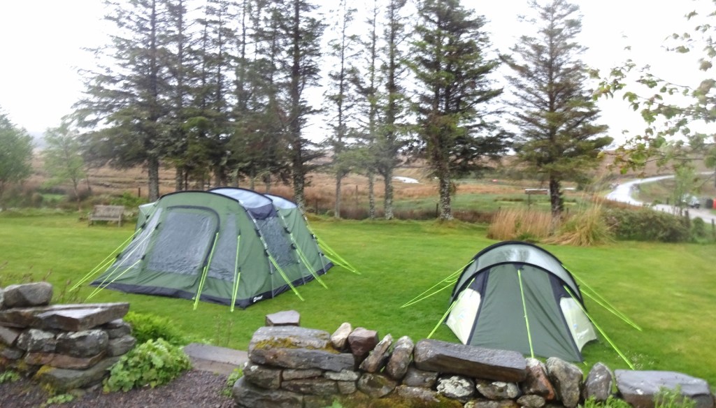
The last stretch from the Bealach Easach to the Crask Inn was somewhat unpleasant, partly because we were tired and it wasn’t far off getting dark, but also because, for the first time on our trip, the midges were out in force – they swarmed around us in their thousands whenever we stopped for a moment’s rest. However, the thought of four walls, a roof, and a warm dinner evidently kept us motivated enough, and we arrived at the Crask at about 8pm.
The Crask Inn is an isolated pub, sitting about thirteen miles north of Lairg and eight south of Altnaharra, which I’d been to once before (see below). We’d booked dinner for the night, and to camp in the grass out the front of the pub – there are a few bedrooms open for guests, but these were booked up that night. On our arrival, we quickly pitched our tents on the grass at the front, before Douglas, the landlord, showed us into the dining room, where we sat down to a very welcome three-course dinner of vegetable soup, bean hotpot, and chocolate pudding with custard. The dining room was set up with one big communal table, so we ended up telling the other residents for the night about our travels, while hearing about theirs – there was a German couple spending three weeks travelling very extensively around Scotland, and several people for whom this was their last overnight on a Land’s-End-to-John’-O”Groats cycle trip.
And that was it! Our trip was over. We slept the night in our tents, and spent the next day in a taxi, several trains, and finally my car as we journeyed back to Cambridge. Hueler felt, alas, a little ill for some of the train trip – could have been the non-mixed Huel, or the untreated stream water, who knows – but fortunately felt better quite quickly. It was a great trip; I’m really glad we went!
The earlier visit
As mentioned above, I visited this map area once before, during the Chase Game in May 2019. The basic premise of this game was that, for three days, I had a GPS tracker placed on me to which my friend Climbing Programmer had access. We both had an equal budget to spend on transport for the weekend, and with me having a 4-hour headstart. His mission was to catch me; mine to not be caught. You can read the full tale of the game in my post about it: here I’ll just present a lightly edited version of the sections of that full post that are relevant to this map area.
I arrived in this map area at around 8pm on day 2 of the game, having caught the last train of the day to Lairg, and then got into a taxi for the 20-minute drive to the Crask Inn. This taxi driver was very chatty, and very interested in what I was doing; by the end of the trip I’d learnt how he used to be an engineer in Leicestershire, but moved up here for the pleasure of it; how he doesn’t make anything from the taxi driving but does it because he likes meeting people; how the local council hire him to take schoolchildren to school, and various other things…

I soon arrived at the Crask, which was indeed a lovely place! They seemed to be doing a thriving trade both days I was there – as a pleasant surprise, they had two large permanent tents up outside, and I got to sleep in one of those instead of using my own little 1-person thing, which was much more spacious and comfortable. (The large tents were no longer present when Hueler and I came back later in the summer, so we used our own tent.)
I had dinner at the Crask – a very pleasant creamy mushrooms on toast starter, a beany casserole thing for main course, and some great rice pudding for dessert, baked, which I hadn’t experienced before, but which is apparently the Scottish way. I went to bed fairly early, and slept very well, making up for my previous night, which had been spent on an overnight coach from Birmingham to Edinburgh – not an experience I’m keen to repeat!
The next morning, I followed my huge Crask dinner with a huge Crask breakfast. The landlord was really nice – he was fascinated by the game, and started giving me all sorts of advice, which was very welcome. I packed up, and left to walk eastwards at about 8:30am.
To the east of the Crask sits the large expanse of wilderness through which Hueler and I walked on the trip that’s described in the main part of this post – aside from private estate tracks, if you travel eastwards, you won’t encounter another road for over 20 miles. My plan, therefore, was just to walk into this, and keep going until 6pm, when the game would end, hoping that Climbing Programmer wouldn’t arrive at the Crask in time to catch up with me. After the first few miles, the terrain would get mountainous, and hopefully very pretty, with Loch Choire to one side of me or the other for a good while.
The Crask’s landlord informed me before I left, pointing to various places on the huge map on the wall in the bar, about a few bothies along the way – i.e. the ones that Hueler and I passed and/or stayed in later in the yar – which was good news, as if Climbing Programmer didn’t get me I’d need to stay out overnight, and I might be able to use one of these and get away without needing to use my poky little tent.

I set off, and after walking the wrong way down the road for a minute or so, was soon on the right track. The going was reasonably flat and not too boggy to begin with, so I made good progress, but about half an hour in, calamity struck.
My phone hadn’t charged overnight for some reason, but I didn’t think too much of this, as I could just leave it connected to my charging pack as I walked. However, after I’d been walking for a bit, I realised that it wasn’t charging at all – the cable that connected it to the charger was broken, and I didn’t have a spare. Now, especially since I had my satellite communicator with me, this wouldn’t be much of a problem, however I was relying on my phone and the OS Maps app for mapping. (I had planned in advance to come here, so I could have brought a paper map as I usually do, but for some reason it didn’t occur to me – I’d put so much thinking into how Climbing Programmer would access mapping, and how I would if things went not to plan, that I didn’t think about this!)

I couldn’t walk off into the wilderness with no map, so I had to turn around and tramp back to the Crask, where the landlord very kindly lent me a copy of this OS Explorer map). I probably lost an hour to that, and more to later thinking that I’d dropped the map (I hadn’t), which was a bit of a disappointment. But still, I continued on happily enough. After a while, after a mildly hairy river crossing, I lost the path, and had to work out my position using compass bearings, which was something I hadn’t done in many a year, used as I am to GPS. Nevertheless, I found the path again soon enough, somewhat perturbed by having seen what seemed to be a person a way behind me, and soon was climbing my way upwards as the path approached the hills and mountains around Loch Choire.
But – all good things come to an end, and I’d lost a good while to going back for the map, and then losing the path. And so it was that, shortly before midday and about 4 miles from the Crask Inn, I saw an orange-jacketed figure round the corner just behind me, and knew the game was up.

And that was it! Climbing Programmer had got me once again. It had just started to rain, and after we stood around talking for a bit, we walked just a little further up the path to the bealach to look at the view down the glen before we turned around. And the view was wonderful, over Loch a’ Bhealaich to Loch Choire and the high ground of the Armine Forest in the distance.

We turned around from the point where Climbing Programmer had caught me shortly after midday to walk back to the Crask Inn, and arrived there an hour and a half or so later – delayed only a little by my questionable decision to try to throw my bag across a little river to make crossing it easier, which then led to my bag falling in, flowing down, and me having to thoroughly wet myself splashing down the river running after it. Arriving at the Crask, we distributed our wet things around the now slightly sunny outdoors, called a taxi, and sat down to some very welcome tea, toasties and cake in the warm as we waited. The taxi came for us at about 4pm, and whisked us to Lairg station and out of this map area!

[1] I went vegetarian two-and-a-bit years ago, after two years of meat-reducing via a “meat tax” (where I’d keep track of the money I spent on meat and pay the same value to charity, doubling the cost of meat to myself).
In my omnivore days, I had quite an old-fashioned palate in some ways, in that I enjoyed such stodgy fare as pies, steamed savoury puddings, stew with suet dumplings, meat paste that comes in jars, and – among the worst of my infractions according to some of my friends – Spam.
Now, I can satisfy most of this urge as a vegetarian easily enough – I like making pies via the “make stew and put some supermarket puff pastry on top” method; these mushroom and chestnut puddings are glorious if a real faff to make; and a roast-dinner-without-the-meat can still feature such delights as roast potatoes, gravy, creamed spinach or leeks and, best of all, stuffing balls (most supermarket dry stuffing mixes, Paxo and the like, are vegan).
However, I do miss some things, and I unfortunately I expect that it’ll be a long time before anyone’s widely selling vegan Spam or meat paste in the UK, as I imagine the demographics who appreciate such things most are probably among the least likely to be going vegan or vegetarian. However, I was very excited recently to find out that a vegan luncheon meat (i.e. Spam) substitute is available in southeast Asia courtesy of the company OmniFoods – I believe it’s a fairly popular ingredient in places like the Philippines. I’ll have to try to get my hands on some somehow. TheVeganKind is selling some of OmniFoods’s other products in the UK, so maybe I can get my hands on some of the luncheon meat sometime soon!
[2]”Ptarmigan” is a Gaelic borrowing, but amusing the silent “p” at the start of the written form comes from someone at some point mistakenly thinking it was Greek, identifying the “tar” bit with the “pter-” word, which means “wing” in Greek, like in helicopter (“spiral-wing”) or pterodactyl (“wing-finger”).
(I do like how helicopter is “helico-pter”, but we’ve reanalysed it as “heli-copter” when we split it apart to use bits of it in other compounds like helipad or gyrocopter. How fun!)

3 thoughts on “443: Ben Armine & Ben Klibreck”