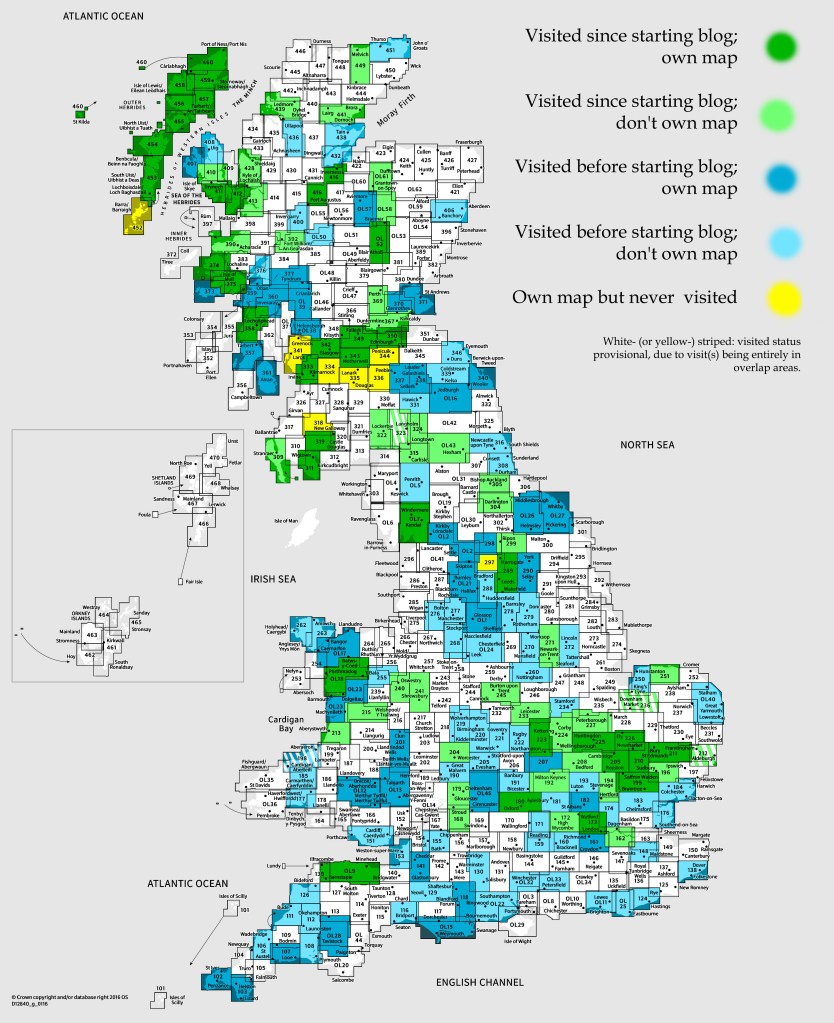
OS Explorer map 449, Strath Halladale & Strathy Point: Melvich & Forsinard – I do not own this map, and had never visited it before starting this blog. Visited for this post Saturday 10th August 2019. This is the first of three posts about a summer 2019 walking trip with Hueler, from Kinbrace to the Crask Inn in northern Scotland over three days.
Keen blog-followers will know that, a few months before this trip, I did the “Chase Game” with my friend Climbing Programmer, whereby he, equipped with a GPS device continuously showing my location, and an identical budget to me to spend on transportation, attempted to catch me over a long weekend, with the whole of Great Britain as our playground. As you can read in my special post about the game, he suceeded – twice.
Now, that game ended in a remote area of northern Scotland, at a point about 4 miles east of the isolated pub the Crask inn, 15 miles north of Lairg, in map area 443. However, despite the fact that I most definitely visited that map area, and haven’t posted about it on this blog yet, I decided not to write about it at that time, because three months later I came back and did something even more exciting – it is the third of the three map areas I visited on the walking trip I’m talking about in this post!
This new trip had its inspiration the morning before the Chase Game ended, when, before I walked off eastwards, the landlord at the Crask Inn landlord told me a bit about the route I was planning to folllow, over a pass to Loch Choire, then up onto the plateau of the Armine Forest. Apparently there were a couple of great bothies on the route, and people would sometimes walk through to/from Kinbrace, a village with a railway station some 30 miles (on foot) to the east of the Crask.

It’s some very remote country, allowing a good 25 miles of fairly direct walking without ever encountering a road, and it sounded like an amazing route. So great in fact that, after I didn’t get to venture very far this way on the Game, I soon planned the trip I’m writing about now, to do the walk!
Hueler is a person whom I’d met a few times before over the previous year or so (at meeting of Cambridge’s effective altruism group), and at an event a couple of months ago, he told me that he wanted to do a long walking trip this summer, being in the work-light zone of having handed in his PhD thesis awaiting his viva. Despite not knowing him very well at that point, I ended up asking whether he wanted to come with me on this trip – and I’m very glad he did, as it was very pleasant!

We set off from Cambridge at lunchtime on Friday in my car (I’d had a half day at work that morning) to drive to Birmingham International station, where we left the car. I very briefly met my mother there, it being conveniently close to her Northamptonshire home, to give her back her handbag, which she’d left in Cambridge the day before when helping me, Vesper and Erithacus move house; and then we headed for the train.
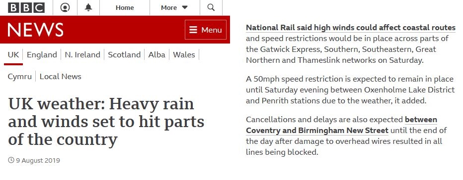
Now, unfortunately, we’d picked a very bad day for rail disruption. As well as knock-on delays caused by power cuts in the south-east, the line between Coventry and Birmingham was closed due to a fallen overhead wire, and there was a 50mph speed restriction on the West Coast Main Line between Penrith and Carlisle due to expected severe weather. Due to all this, our initial train was cancelled (well, diverted away from the point at which we were going to get on it), so we ended up arriving in Glasgow two hours later than planned, and with two unexpected changes.
(On reflection, though, this wasn’t terrible, as we still got to bed in our hostel that night at a reasonable hour, and a 2-hour delay meant we got a full refund – if we could’ve picked to travel for free but two hours slower, we would probably have done that anyway! And the next day, the expected severe weather had arrived in the form of flooding, and the West Coast Main Line was fully closed.)

We checked into our Glasgow hostel room after a hasty dinner assembled from a Chinese food bar and a Sainsbury’s near Glasgow Central station, and were very impressed by how hotel-like it was, until we discovered that the shower had no light, was scalding, and more of a sad trickle than a stream.
Having slept well, we hopped on our 0707 train to Inverness the next day, then made our connection on the Far North Line, as they’d held the train for the fifteen or so of us coming from Glasgow who were delayed by a quarter of an hour. We arrived at Kinbrace on schedule at 1334, thereby entering this map area, and with us sorting out our packs and tightening our laces as the train receded into the distance leaving us at the already very isolated station – our trip had begun!

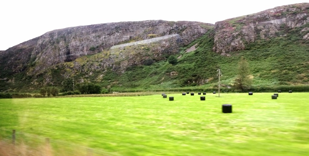
Our walk that afternoon would take us out from Kinbrace – which consists entirely of the railway station, a handful of houses, and (this being Scotland) two churches – at first along the B871 for about four miles until the head of Loch Badanloch, following the River Helmsdale. At that point, we’d leave the road, following an estate track for another five miles or so to Gearnsary, where we’d be overnighting. It’s actually only the first section along the road that’s in this map area, as Badanloch Lodge (at the head of the loch of the same name) is just over the boundary into map 448.

And so we set off! Those few miles passed quickly, the going being flat and straight as we admired the land we were passing through, already very open and empty, though we were still on the road for this section – indeed the B871, single-track for its whole length, never approaches a sizeable village until its and at Bettyhill on the north coast. The most notable occurrence was that the same farmer passed us about three times on a quad-bike pulling a trailer with three cheerful collies in it, and it was soon time to leave the road.
We had a rest on a convenient bench near the turn-off for Badanloch Lodge, and it was there that Hueler, for the first time of many, mixed himself up a shaker of the meal-replacement drink Huel – his nickname for this blog comes for the fact that he made the brave decision that, in order to save weight, his food for this trip would consist entirely of Huel. There were many more Huel-related adventures and misadventures to come – for some more of those, and to continue the tale of our trip as we crossed the river and started along the estate track towards Gearnsary, see my next post!


4 thoughts on “449: Kinbrace”