OS Explorer map 460, North Lewis: St Kilda & Flannan Isles – I own this map, and have visited it before starting this blog. Visited again for this post 16th August 2018. (This is the eighth of fourteen posts concerning my July 2018 trip to Harris and Galloway with my Cambridge friends.)
So, my previous post had me and my friends Erithacus, Millicent, Vesper and Cheremy on a day trip out from the holiday cottage on Harris where we were staying; we went to south-west Lewis and visited a beach and a probably-not-actually-a-ruined-nunnery. After this, we headed north, visiting the Callanish Stones and Carloway Broch – both wonderful places, but also both places that I’ve posted about before, being as they are in the Central Lewis map area. (In fact they’re both in overlap areas of that map, Callanish overlapping with 458 West Lewis, and Carloway in this map, 460.)
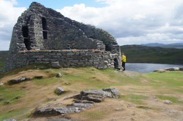
Carloway Broch was wonderfully impressive as always – for an Iron Age structure the scale is just quite unbelievable, especially since the whole thing is dry-stone-walled, and it’s impressively very still present, you can clamber about in the hollow outer walls up to the higher levels. Everyone appreciated it, and we did something there I’d never done before: we all climbed inside a chamber accessed by a tiny doorway that you have to crawl through, which opens just onto the entryway to the broch. It was actually surprisingly spacious inside and we all sat in there for a bit!


Now, at Callanish a little while before, we had noticed a lady who, in her general appearance but especially her distinctive hair, looked rather like one of our beloved lecturers. This lady, whom we therefore named American Ros (she being American), also turned up at the Broch once we’d been there a few minutes, and we had a bit of a conversation with her – we also called to her from inside the side chamber and she stuck her head in for a moment.
From the broch we drove for another forty minutes or so, to Lewis’s northern end, where the first of our two stops was at St Moluag’s Church in the village of Eoropaidh, about a mile south of the northernmost point on Lewis. The church was reached by means of a footpath between two classic narrow crofts, one of which contained some very photogenic sheep.


On this trip, as we did on the Holy Island Trek, we were keeping our Annal, a collaborative diary in which one of us would write the events of each day. I haven’t quoted the Annal yet for this trip, so here is some:
The church, 12th- to 15th-century in date, was very pleasant, having been refurbished without any dodgy bits, it was agreed. Signs told us its tale – it had been a centre of healing and pilgrimage, and we were intrigued to hear that if the afflicted one were too ill to travel, a “sufficiently detailed” clay model of their injury would do just as well.
It was now an Episcopalian church (i.e. the Anglicans in Scotland), having been bought by them in the 20th century, and is run from the Episcopal church in Stornoway, still getting one service a month. Of particular interest to us was that it was once upon a time dedicated to St Máel Rubha, of stick fame. Millicent, among whose many interests lives historical travel narratives, also discovered an amusing story about the church in the writings of Martin Martin, who came to Lewis in 1695 and reported seeing the locals perform a “pagan ceremony” to honour the sea-god Shony.

From St Moluag’s, we drove just a little further north to the Butt of Lewis, the location of a lighthouse, some very dramatic cliffs, and Lewis’s and the Hebrides’ northernmost point.


Once we’d got out of the car and were walking around the front of the lighthouse to get to the clifftops behind it, Erithacus decided to ask me to clarify the place name, saying “so, is this whole thing the Butt?”. Unfortunately, she said this rather loudly just as some fellow-tourists were walking by us, which resulted in in a giggle from a stranger.
Now, when I’d been to the Butt before, I’d noticed that on some of the exposed clifftops, the grass isn’t actually mostly grass, but is some strange sort of succulent plant with very tiny blobby leaves. Since I’d told the others about this on the way, everyone knelt down to have a close look, which led to us presenting something of an odd picture for a while.

")
Despite sending pictures to a biologist friend, I never quite worked out what that plant is.
Once we’d satisfied ourselves with the Butt, we got back into the car and, it now being quite late, headed home to the cottage, stopping in Stornoway for some shopping in Tesco, and to buy some hair straighteners from Argos. It had been a long day!

Previous visits
I’ve been to the north of Lewis just once before, on my summer 2017 trip to Harris with my school friends Cabbage and Joystick. Now, they actually came up to Harris without me, since I was busy with something or other – they drove up to Scotland in Joystick’s car, stayed the night at our friend Geochunderer’s house in Fife, and then drove to Skye the next morning to get the ferry to Harris. They had some problems with the ferry and had to stay an extra night on Skye itself, which then caused additional problems as they couldn’t find accommodation on such short notice, but they eventually found somewhere to stay.
It was, I think, two days later when I arrived at Stornoway airport, the two of them driving up to collect me, from where we went to the Callanish Stones, Carloway Broch, and eventually the Butt of Lewis. It was on that occasion that I discovered the interesting not-grass, and we generally enjoyed the dramatic scenery before driving back to the cottage.
")
")


3 thoughts on “460: North Lewis”