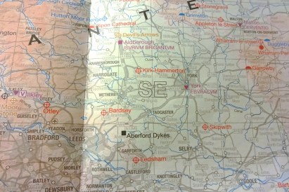
OS Explorer map 289, Leeds: Harrogate, Wetherby & Pontefract – I own this map, and have visited it before starting this blog. Visited for this post 4th January 2018.
This post continues directly from the previous one, with my carful of six people driving up the A1 on our way to Scotland for the ASNC Trip to Argyll. (Our video of the ASNC Trip is on YouTube on the ASNC Society’s channel – the section corresponding to this blog post runs from 22:34 to 25:43)
We were stopping for the night in Cumbria on the way, so didn’t need to get all the way to Scotland in one day, and therefore had the luxury of doing a driving trip as it should be done, namely with lots of stops, if possible at interesting places. With this in mind, before we drove off from Newark (in the last post), out came the OS Ancient Britain map. This map is brilliant. [1] It shows Britain with sites of historical and archaeological interest marked, colour-coded by which of several periods the site belongs to; the last of these periods is Early Medieval, ending according to the key at 1066 [2] – naturally this is the most beloved of ASNaCs, so it’s always the red I’m looking out for!
We decided to stop at Bardsey to look at their Anglo-Saxon church,and so off we went, and duly arrived there a little after an hour later! The Many-Named used this opportunity to brighten our by introducing us to the delightful Hamlet: The Musical, which unfortunately is not widely available these days – The Many-Named recounted their great difficulties in obtaining their precious CD.
We arrived in Bardsey, after leaving the A1 and driving through Collingham (of which I have memories – see below); we eventually found the church by locating the road called Church Way or something – there were no signs for the church or anything.
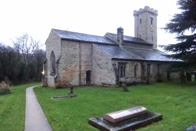
The church was very pleasant; it did indeed have an Anglo-Saxon tower, [3] the lower half of which was rather earlier than the top half. (The crenellations, in fact, are later medieval). There were also lovely Christmas decorations, and it was nice to see that it looked like it’s still a very well-used church with an active calendar.
")
")
")
Alcove Gremlin has a thing for squirrels (she does a delightful squirrel impression and I seriously considered her nickname being The Squirrel Whisperer), and she was delighted to discover that of the knee cushions had a squirrel on it. Also pictured are Millicent and Vesper below an Anglo-Saxon-looking window, and the church’s roof, of which both I and Alcove Gremlin sent pictures to Active Pumpkin, since she has a thing for ceilings. We then wrote in the visitors book, and were soon back in the car after a very pleasant visit, heading northwards once again!
Strictly speaking, we had one more stop before leaving this map area, at Wetherby services for petrol and the toilets. There I had to drive around the services to get to a further back petrol pump because the first one I stopped at had the pump on the wrong side – I’d never filled up this car before and didn’t know which side it was. I tried to reverse to get to a different pump, but a honk from a driver behind scared me off that, and so I went around.
Previous visits
I’ve been to this map area several times before, mostly in fact when stopping on trips up or down the A1! In 2014, I went on a trip to Scotland with school friends Cabbage, Climbing Programmer, and Joystick; we also met Geochunderer up there. (That trip has featured on the blog before, in my entry on the Cuillin Hills.) On the way up, we were indeed using the A1, and stopped for lunch using my preferred method of getting off at a random motorway junction, and driving into a village in search of a pub. [4] This took us to the delightful Collingham.
")
")
")
I have no idea why the one building I decided to take a picture of in Collingham on that trip was Uffizi Interiors. We ate dinner in a pub as planned, which I remember being very pleasant, and indeed I recall that our main impression of Collingham was that it seemed really very posh for a random Yorkshire village – there was even a Porsche garage!
In 2016, on the way up to Lindisfarne for the Holy Island Trek (about which see e.g. the Lockerbie entry, and a footnote to The beginning), we stopped for lunch in Pontefract, also in this map. I unfortunately didn’t take any pictures until we got to Lindisfarne, but our annal, the collaborative diary we kept on that trip, reports:
After a stop for fuel and socks, we were on the road at last. Whilst visiting the death place of Richard II, we made our way into the concealed Tesco. The lack of customer toilets led us to the fairer pastures of Morrisons, where the café gave us lunch in full accordance with the laws of capitalism. Whilst perusing the shelves in search of sustenance, [Erithacus] revealed her weakness for wonky carrots. After successfully smuggling our purchases through Tesco we were reunited with Hilda. [Hilda is my car] [5]
“The death place of Richard II” is glossed with hoc est urbs pontefractae – we did quite a lot of glossing to that annal, because we’re medievalists and we’re strange like that. Anyway, yes, the Tesco had a very small and unassuming entrance on the high street that led through a little tunnel to the very large store.
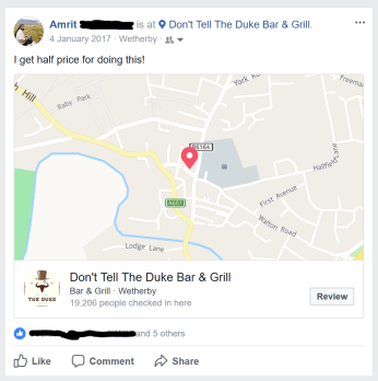
I have also once been on a holiday where I stayed near Wetherby and visited, I think, Harrogate, but I’m not going to talk at length about that one. Here are two pictures from Wetherby, one of a huge amount of meat on a plate (it was a shared plate between two I believe), and one of a Tardis that stood outside the police station.
")
")
At the lots-of-meat restaurant, there was some kind of special offer on whereby I had to do a Facebook post with their hashtag in order to get half price off. Since I’ve nothing better, let’s end with the thoroughly boring thing that is a screenshot of that Facebook post… (Well, not end, because of course there are the footnotes, with which this post has become unusually well-endowed!)

[1] Millicent likes telling tales of how his family have come to hate the Ancient Britain map, given how it is likely to result in delays to their journey at places that he finds more interesting than they…
[2] I’m sure though that, especially in Scotland and Wales, some of the sites marked in red on the Ancient Britain map are later than 1066. Indeed it’s a bit of a shame that the map ends with early medieval, since there are plenty of later medieval sites that are wonderful to visit, but I suppose it would get a bit crowded. And still, used together with things like the English Heritage / Historic Scotland maps on their websites one can get fairly comprehensive coverage for planning a trip. I do like, though, still to have a look at the stuff in the “old stuff” font on the Explorer and Landranger maps when I’m at places, as sometimes that will be the only thing that lets you know a historical place is there. (As was the case with St Columba’s Church in by Loch Awe, about which see my forthcoming post about map 358!)
[3] Today – that being the 16th January – I was speaking to a fellow graduate student at Corpus Christi, to whom I’d never really spoken before; he was an Art History student, and it so happened that his thing is looking at Anglo-Saxon church towers! It having been mentioned that I was from Northamptonshire, Brixworth and Earls Barton were mentioned, but no, I said, those weren’t the ones I went to this Christmas, I went to Escomb and Bardsey, which he of course, knowing much more about such things than I do – I generally rely on Millicent to tell me about churches when I’m there – knew of. This story isn’t really going anywhere; it was just a pleasant chance discovery.
[4] While the strategy of getting off the motorway and driving wherever in search of a pub went well this time, it went much worse in 2015, when Cabbage, Joystick and I drove up to Scotland for Geochunderer’s birthday – on that occasion, we ended up going to a very dodgy Mexican restaurant in Wigan and wasting two hours on getting lost. We had decided at a junction to head towards Wigan rather than Chorley, and decided this was probably a mistake afterwards, until we told Geochunderer’s mother about it, who assured us that Chorley is not very pleasant. (Geochunderer’s family are very pleasant, to the extent that it is a joke among us to imply to Geochunderer that we actually only go to see him because we like his mother, father, sister, and dog.)
[5] Hilda, my car, is of course named for St Hilda of Whitby. At the ASNC Society’s Black Tie Dinner in 2016, we had to write our favourite ASNaC figure in the booking form, so that the responses could be added up and the winners announced. Alas, despite my putting her, Hild did not win, the winners being in fact Dr Dance (our Old English lecturer), closely followed by Bede and Professor Russell (our Welsh lecturer).
Hilda is a Fiat Doblo, a make of car not exactly known for its beauty; she is rather large and box-shaped. I chose her, of course, because being boxy means that for a given chassis size, which having bigger makes it harder to drive and park, you get the most internal space, for carrying around stuff and people, and I like carrying around a lot of stuff. On the above-mentioned trip to Scotland for Geochunderer’s birthday (as on many other occasions), Hilda was good-heartedly ridiculed by Geochunderer’s friends, leading to “Fiat Doblo” becoming something of a verbal meme for those few days.

5 thoughts on “289: Bardsey”