OS Explorer map 413, Knoydart, Loch Hourn & Loch Duich: Kyle of Lochalsh – I have visited this map before starting this blog, but do not own the map. Visited for this post 30th March 2018.
My last post told of the 29th–31st March, when I stayed on Skye with the Dearest Progenitors, however there was a gap in the narration in the afternoon of the 30th, when we took the ferry over to Glenelg for a few hours, entering map 413.
So there are three ways to get between Skye and the mainland. One is the Skye Bridge, linking Kyle of Lochalsh and Kyleakin. The second is the big Calmac ferries between Armadale and Mallaig. [1]
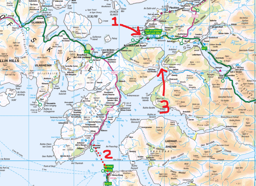
There is a third though, rather less-used, a little ferry going between Kylerhea and Glenelg. This is the point where the island and the mainland are closest, only a few hundred yards apart, so it makes sense as a crossing point, and indeed has been used as one for a very long time – however, the termini on either side are in rather isolated places, presumably explaining why this didn’t remain a major crossing in modern times. The Glenelg ferry is an independently run heritage service, and operates in summer only, primarily for tourists. The exciting thing about it is the ferry itself – it’s a tiny little manually operated turntable vehicle ferry (see photo)!

The little board in the information point at one end of the slipway had a lot to say about the history of the thing – such ferries were at one point the main kind of vehicle ferry, operating all over the Highlands and Islands, and this is the only one remaining. The vehicles drive on to the platform, at which point the crew manually push it, turning it back into alignment, and turn it again at the other end for the cars to drive off again.
So yes, from Armadale we drove to Kylerhea, the last several miles of which are along a windy single-track road over the hills. We arrived, and awaited the ferry for a good while, as we’d turned up during the crew’s lunch break and it was moored at the other side of the water. During that time I took a brief wander up the hill, partly to have a wee, but also just as something to do.

There was also an old telephone box with a sign that didn’t look like it had been relevant for rather a while…

The ferry eventually turned up, and on we got – we were the only ones. Father Dearest enjoyed himself chatting to the ferrymen.

At the other end, we drove into the village of Glenelg, where we stopped for lunch in the little café in their village hall. It was very pleasant!
")
")
")
Our next destination, and the reason why I wanted to come to Glenelg, really, was the two brochs, Dun Troddan and Dun Telve, that are in the next valley along, just past the little settlement of Eilanreach.
")
")
Brochs are cylindrical Iron Age dwellings that are found all over the west and north of Scotland. Most of them that still have visible structure above ground are fairly minimally present now, since the convenient stones have usually long since been re-used by people building their houses, but these two are pretty intact.

Brochs have a double outer wall with a spiral staircase between them, and in Dun Troddan especially this was very well-preserved. The broch that I know best is Dun Carloway on Lewis, and although that one too is very well-preserved, and one can clamber through the staircase, its walls are a lot lower, especially compared to Dun Telve.
On the way back towards Glenelg we had a quick stop to walk across a field to a little river, which was very pleasantly supplied with smooth round stones – in my not-so-very-much-younger days I used to love coming to places like this and spending hours building little dams with sticks and stones and mud, diverting the water about.
")
")
Mother Dearest stayed in the car as Father Dearest and I walked down, as the field was a little muddy. The other notable occurrence that happened was that there was a holiday let that we passed that, for no particular reason, Father Dearest was utterly smitten by; I took a picture of the sign and we are to return there sometime in the future, apparently.
We then got back into the car, drove back to the ferry, and were soon back on Skye and returning to our hotel!
Previous Visits
So the A87, which is the main road to get you to the Skye Bridge, goes through this map, so I’ve travelled through it many times before. However, I have also visited it properly, just about.
That occasion was on the July 2015 trip that featured in my last post and a few others, when I came to Scotland with Father Dearest to look at houses, which ended up with us getting our Harris cottage. In my previous post, about map 412, we stayed the night in a hotel in Kyleakin, before the next morning going to look at a house in Glasnakille (on which see my Cuillin Hills post). We had two more houses to look at that day, which were both on the mainland, but pretty close to Skye.
Now I’ve been to map 428 before (Torridon), and so areas in the overlap with it wouldn’t count for a new map. The map below shows the locations of the two houses we went to see; the one to the south-west is only just outside that overlap, and it was on the strength of that that this map counted as visited before now.

The first one we went to see was the one further south and west, was, oddly, made of wood. It also had some questionable tartan carpets. The owner also showed us around himself rather than an estate agent. There was a very nice little grassy area with a bench in the bushes behind it, up a staircase carved into the slope.
")
")
I think we weren’t all that impressed with it; I feel like it felt like it’d be in need of a lot of attention, and it also had a boiler system that the owner had constructed himself or something like that.
The second house was very modern and sleek. I think it was rather over our budget though.
")
")
From there, we drove all the way to Inverness, returned our hire car (which we’d collected from the ferry port at Uig) at the airport, and were off home!

I think I also stopped in Kyle of Lochalsh with Cabbage and Joystick on the way back home from our trip to Harris in summer 2017 to use the toilets; we had to go off the main road into a little square to do that so it might just about count as a visit according to my Rules.
A small announcement
There is one more thing to say, in that I just added a feature to my blog. This is the Chronological Index of Pre-Blog Trips page, which lets you wander through my past in order – so when I talk disjointedly about past trips about the country as I happen to revisit those places, you can read about those past trips as a connected story.

[1] Mallaig is also the terminus of the West Highland Line, a train ride that I really would like to go on at some point, but somehow haven’t yet managed to despite the huge number of times I’ve been in Scotland these last few years.

4 thoughts on “413: Glenelg”