OS Explorer map 456, North Harris & Loch Seaforth – I own this map, and have visited it before starting this blog. Visited for this post 1st January 2018.
The last post ended with me and the Dearest Progenitors in our cottage on (South) Harris, on our third morning of our stay there. That day we, it being the main thing there is to do and a very enjoyable one at that, planned to have a go at going for a walk. We were intending to try the walk to the eagle observatory at Miabhag on North Harris again, having not done that the previous day because of the bad weather forecast – although in the end it hadn’t been particularly rainy. In any case, this morning was sunny enough that if one looked out of a window one could easily believe it to be summer.
After some eggy bread for breakfast, we got into the car and drove off, going past Tarbert on the A859 to turn onto the B887 to Hushinish/Huisinis. This is a delightful single-track road that has, I think, the loveliest views of any of Harris’s roads – and they all have good views, without exception – plus it leads to the wonderful Huisinis beach. (I realise I’m being a bit inconsistent on this blog as to whether I use Gaelic or English spellings when both are available. Meh.)
As we drove, it started to rain, and upon arriving at the car park for the eagle walk, conditions didn’t look particularly amenable to an enjoyable outing, so we gave up and drove back the way we came. We encountered a slight blockage in the form of a herd of cows in the road.

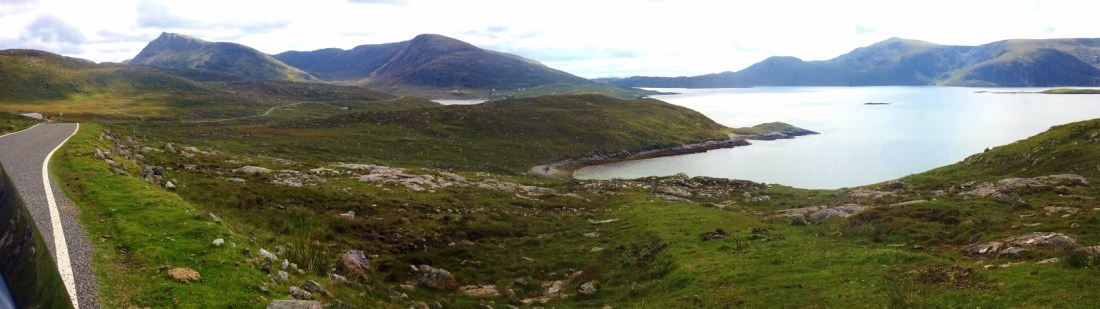
Instead of just driving back to the cottage and giving up on doing anything out today, we decided to have a go at driving down the road to Rèinigeadal, which we had somehow never yet managed to do despite our many trips to Harris these last few years. Rèinigeadal is a village at the far eastern point of North Harris, which is three or four miles from the nearest other settlements, and divided from them by some big old mountains. It is notable for not being connected up to the island’s road network until 1989.
It’s always fun looking at the place-names around here, since you get Gaelic, Norse and occasionally English/Scots colliding with each other all over the place. It would be a sensible thing for me to do to get a book about the place-names of the Western Isles or something, but of course I haven’t done that yet, so I usually just end up doing nothing more than getting excited when I see a name whose elements I think I can recognise. Some of the Gaelicised Norse names are fun to spot, e.g. Loch Langabhat and Loch Lacasdail, which I assume come from something like lang(a)vatn and laxdalr, “long lake” and “salmon valley”. Looking at Rèinigeadal, I can be confident about the second element being dalr again for “valley”. My immediate inclination is for the first element to be from a “rain” word; Icelandic has rigning and something like regn, I think, and I assume our rain is from something like ræġn or reġn in Old English. But then, in Rèinigeadal form the n comes before the g. Perhaps some kind of metathesis, or, very likely, my two-second etymology is just entirely wrong.
So yes, we drove a little way up the A859 towards Stornoway before taking the turning onto the Reinigeadal road. Near the end, once we’d reached the sea, we got out for some photos and I walked a little way to a little rise for a better view.

One of the reasonably few footpaths marked on the Explorer maps of Harris is the one that goes across the hills from Rèinigeadal and the abandoned village of Moilingeanais; the path was, before the road, the primary land link to the rest of the island. We could see it from the road and I’d very much like to walk it someday. It’s not all that difficult or anything, but like with so many other things here, I still haven’t done it despite having been so many times!

Once at Rèinigeadal we decided to walk a very short way along the path and back just to see what it was like before going back to the cottage. We certainly would like to return and walk it properly in better weather and when we’re better equipped! (Father Dearest doesn’t have any walking boots with him this trip.)
")
")
But yes, after a quick turn down and back up the path and a couple of pictures, we got back in the car and started to drive back.

When we were back on the A859, something very dramatic happened: a group of five or so deer ran across the road in front of us! We then parked up to watch them recede into the mountains to the west. (No pictures as they ran off very quickly!) However we then saw two more deer, both stags this time, on the other side of the road!

They then moved off back into the valley, so Father Dearest and I decided to cross the road and walk to the top of a little rise to be able to see them better. We then watched them, with eyes and the help of some binoculars, as they wandered up the road and eventually crossed a fair way off. This was very exciting; it was the first time any of us had seen deer here!
After that, we returned to the cottage for the rest of the day, to depart on the ferry back to Skye the next morning.
Previous visits
I have been to North Harris many times before, since we have a cottage on South Harris, and so, similarly to my South Harris post, here are just a couple of pictures with commentary.
")
")
These two images are from summer 2017, when I came to Harris with my school friends Joystick and Cabbage. It was a wonderfully warm and sunny day when we went to Huisinis beach (pictured), and we stayed there for several hours, having brought a packed lunch, and even dared a dip in the North Atlantic. It was indeed too cold for me to be comfortable, but I’m sure many would find me lacking for that! Huisinis beach proper is rather large, but there are three smaller beaches just along the coast from the main beach, of which this is the second; there were a few groups on the main beach when we arrived, but we had our beach to ourselves for the whole time we were there except for one brief appearance by a dog-walker. (The OS map only marks two beaches out of the four, but we had seen them all from the road in.) The beaches on Harris really are wonderful.
")
")
These two pictures are from summer 2016, when I came to Harris with my parents and two young cousins (once-removed). We went to Huisinis beach and messed about (there were very many huge beached jellyfish that day), but afterwards took a walk on a path along the coast, to what my map tells me was Loch na Cleabhaig.
On that trip we had quite the adventure travelling up to Harris. The plan had been to fly from Birmingham to Stornoway, changing in Glasgow, but our first flight was delayed sufficiently that we missed the second. The next flight wasn’t until the next day, so the airline offered to put us in a hotel until then, but we took a refund instead, and got a taxi into Glasgow, then a train to Inverness, then another taxi to Ullapool just in time for the 8pm ferry to Stornoway. Our first taxi driver was rather a conversational menace, deciding because of our looks to address us with his few words of Hindi, which we don’t speak, and then not shutting up the whole journey as he talked about the Indian community of Glasgow. (Of which, presumably, he wasn’t a member.) The second taxi driver was a menace for more practical reasons, in that his car drifted alarmingly off the road onto the verges several times. But we got there in the end, and on the same day, which is better than the plane would have done.

3 thoughts on “456: North Harris”