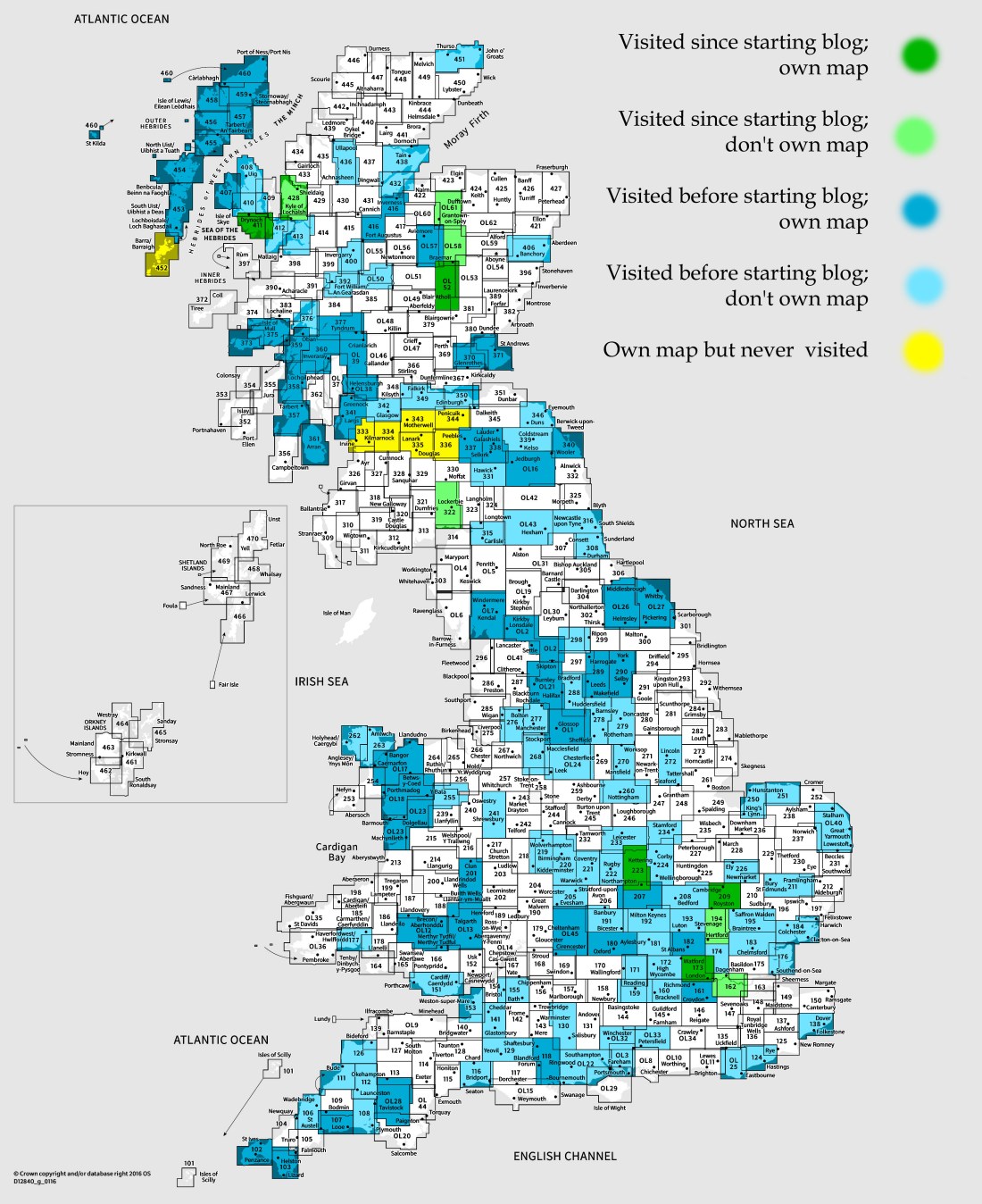
OS Explorer map 211, Skye – Cuillin Hills: Soay – I have visited this map area before starting this blog, and I own the map. Visited for this post 29th December 2017.
This post continues directly from the previous one, with me and my parents in the car coming over the Skye Bridge, on our way to get the ferry to Harris from Uig. Before our 2pm ferry, we wanted to do some touristy things, and so had a vague plan to go to see the Fairy Pools, as although we’d been to Skye previously, none of us had ever been there. As it was still snowy, we thought it was definitely possible that this would not be possible, whether because of the roads being impassable or the walking being too difficult, but still we thought we’d have a go and turn back whenever it became necessary. Before this, we intended to go to the Co-op in Broadford to stock up for the next couple of days, [1] but we decided to go straight to the Fairy Pools for maximum time in case of delays.
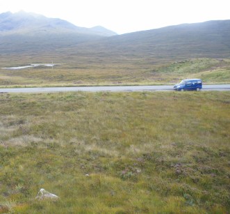
We left the A87, Skye’s biggest road, at Sligachan onto the A863, and then onto the B8009, and finally the single-track Glenbrittle road, and as the roads got smaller, things got snowier.
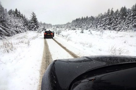
The Glenbrittle road was not gritted, and we didn’t have problems driving along it since this time we remembered to turn on the “off-road mode” in Mother Dearest’s car, but we did pass a French group in a smaller car that had got stuck and had to push. (The Dearest Progenitors waited at the foot of the little rise while I walked up to help the Frenchies push, but naturally once I got there they were free.)
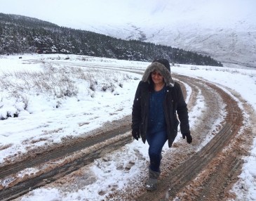
Reaching the Fairy Pools car park, we decided to have a go at the walk and see how it went, and so off we went. I had brought this map with me, so I could actually use it! We weren’t very well prepared, I must admit; Father Dearest only had inappropriate shoes and no gloves, and I was wearing a wool coat. Father Dearest and I ended up sharing the pair of gloves, he wearing the right one to hold his walking pole and keeping his left hand in his pocket, and I doing the opposite.
We went down the reasonably steep track for a little while with a family just behind us who were speaking something Scandi-sounding.
")
")
It was rather slippy, but the sticks helped. However, as we neared the bottom of that slope, it became clear that we’d have to cross a stream by stepping on snowy rocks and, although I managed it with the help of a stick, it was really very slippy and so, eventually, we decided to turn back and return someday, either better equipped or, more likely, just when it wasn’t snowy! In fact, I’m not entirely sure whether the blueness for which the pools are famed is even present in winter – is it?
Looking at the map, we were only about a third of the way to the Pools when we turned back, and there were more streams to be crossed, so it was probably a good decision considering the time, too. And, eh, it was still pretty, especially the very large snowy mountains to the south.
")
")
We then returned to the car and started to drive again. However, at the initial steep section in the road back, adversity struck – about half way up our wheels started to slip and we were sliding back down the road backwards, and were only able to stop when Father Dearest very competently steered us into the bushes at the side of the road. Mother Dearest and I then had to get out and push the car up the slope, but fortunately this worked well enough, especially when two passersby gave some additional assistance.
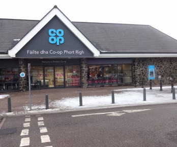
Since we’d stopped the walk early we had plenty of time, and so we decided to stop at the large Co-op in Portree to stock up on foodstuffs before continuing to the Uig ferry. (This is by now outside this map area, but the Co-op, being a stop for provisions along our route of travel, doesn’t count for a map.) A pleasant, presumably local, lady complimented my hair at the self-checkouts, which was nice! We bought chicken thigh fillets for Father Dearest to make curry with, as well as various other things, such as the all-important Cravendale milk. [2]
And then, of course, we proceeded to our ferry. Mother Dearest went and bought us tea as we waited in our car in the queue, then boarded the ferry. We had lunch in the ferry’s café, and all went well; we reached Harris at about twenty to four as planned, about which see the next post! Views from the ferry:
")
")
Previous visits
I’ve been to this part of Skye twice before, not counting times just passing though. The first was in summer 2014, when my school friends Cabbage, Joystick, Climbing Programmer and I went on a two-week road trip around Scotland. We had by this point been at university for two years, and the reason we came to Scotland particularly was that Geochunderer, the fifth member of our group, had moved up there (he both went to university in Scotland and his family moved up), so he’d be able to join us for a few days.
We had been in Edinburgh for two days and the Uists for two, before getting the ferry to Uig and staying three nights on Skye. We stayed in a campsite near Dunvegan (outside this map), and had various adventures such as a boat trip, and such as when my car fell into a ditch, [3] but we came to this map area only on the last day as we were leaving Skye to go to our next campsite at Fort Augustus, where Geochunderer would be joining us and we’d stay the next five nights. Now this was over three years ago and I don’t have much in the way of records of this trip beyond pictures since we didn’t even prebook our campsites – I have only a vague plan we made before leaving, and a record of the money we spent on joint costs, from which we worked out how much each of the others should pay me back for things (I think the arrangement was that I would pay for every group cost, to be paid back later). My SMS history shows no texts at all during the period of this trip exactly, so I suppose I must have left my phone at home or something and been using a spare ; Facebook message history only has irrelevant messages. Therefore some details may be sketchy!
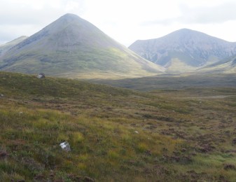
We drove south from Dunvegan, I assume on the A863, where we passed various pretty mountains.
Apparently we stopped for me to run a little way off the road, because there is this picture of the car on the road, which some judicious zooming shows has the others (well, Cabbage and Joystick at least [4]) still sitting in it:
We didn’t go straight to Fort Augustus, instead stopping a couple of times, notably making a significant detour on Skye to Elgol, I think because Cabbage had some vague idea that dolphins or something could be seen from there. (I have no idea whether this is true.) In any case, I don’t think we did much more than drive there, get out of the car and walk about a little, and then get back in and drive away.


Elgol and the road to it are breathtakingly pretty though. I have never properly entered the Cuillin hills on Skye, and would very much like to. On another trip it will have to be!
The second time I have visited the area was in summer 2015. This was the year when we bought our Harris cottage, and the trip in question was when Father Dearest and I came to Scotland for a few days to look at several potential houses. We used to own a little log cabin by the river in Stratford-upon-Avon, but having had that for over ten years, we had recently sold it, and the idea (which we came up with while in Ireland earlier that summer), was to replace it, as it were, with a Scottish cottage. The Dearest Progenitors and I had been to the area before (well, not to Skye, we only passed rapidly through there), in summer 2013 with a visiting cousin, which was where we got our ideas from; I particularly had loved our all-too-short time in the Hebrides.
Anyway, having looked at a couple of houses on Lewis and Harris (including the one we ended up buying), we came to Skye and looked at and one or two in the Dunvegan area, then stayed the night in a hotel in Kyleakin. Father Dearest and I came to look at a house in this map area the next morning, in the not-really-even-a-village of Glasnakille across the ridge from Elgol.
")
")
")
The house was very pleasant, and in a beautiful location; it was our second favourite of the six or so that we viewed on that trip, but in the end we chose our current cottage on Harris over this one mainly because this one was rather poorly connected, being at the end of a 45-minute drive down the Elgol road from Broadford, where the nearest shop, petrol station, and so on were, or indeed from anything else. In Miabhag on Harris, by contrast, we’re but five minutes from Tarbert and all of its shops, and there are a lot more things to visit within a short drive.
From viewing this house we briefly had a stop in the estate agent’s office to look at the details of a couple of other properties, then headed over the Skye Bridge to look at a couple more houses in the Kyle area.
[1] The closest shops to our Harris cottage are in Tarbert, which is very close by, only about three miles I think, however the grocery shop is rather small and closes early. (And, like all shops on Harris and Lewis, is also closed Sundays.) We were planning to drive up to Stornoway the next day, where there’s a huge Co-op, so for now we just needed one day of food. In the end we decided to miss out the Broadford Co-op because we were arriving early enough in Tarbert to go to the little shop there, but in the end we did end up shopping on Skye, see below.
[2] Mother Dearest and I find it eternally amusing quite how exciting Father Dearest finds the prospect of making chicken curry. It is a very regular thing for us to eat; when I’m home we probably have it once a week, and yet whenever the possibility arises of our eating it, he finds it incredibly exciting, as if he hadn’t tasted his favourite foodstuff in months.
[3] I fell off the side of the single-track road while passing a cyclist. The fully documented tale of this occasion will have to wait until I blog about map 407, but what is notable more widely is that this was the first of three times that I have fallen off roads into ditches while driving in Scotland – I also did so once on Harris, and once on the south side of Loch Awe (a place I will be revisiting in less than a week, so look out for my post about map 360, where the tale will be told in full!). These three times have been on each of the three trips when I drove to Scotland. After the first two it was just a bit of a joke that every time I drive to Scotland I fall in a ditch, but three out of three now makes me a little apprehensive about the fact that I’m going to be driving to Scotland again in less than a week – and indeed along the same road I fell off before…
[4] I am reminded here of the engineer, physicist and mathematician on a train to Scotland: upon passing a black sheep, the engineer commented: “Hmm, it seems Scottish sheep are black”. “No”, said the physicist, “all we know is that some Scottish sheep are black”. “You are both wrong,” says the mathematician. “All we can say is that there is at least one sheep in Scotland, and at least one half of that sheep is black”.
I don’t quite remember where I learnt that joke. I certainly knew a whole lot more physics jokes back when I studied physics.

11 thoughts on “411: Skye – Cuillin Hills”